Quantcast
Channel: Traveler Guide
Viewing all 1406 articles
Browse latest View live

Sans Souci

$
0
0
Executive summary by darmansjah

Sanssouci is the former summer palace of Frederick the Great, King of Prussia, in Potsdam, near Berlin. It is often counted among the German rivals of Versailles. While Sanssouci is in the more intimate Rococo style and is far smaller than its French Baroque counterpart, it too is notable for the numerous temples and follies in the park. The palace was designed/built by Georg Wenzeslaus von Knobelsdorff between 1745 and 1747 to fulfill King Frederick's need for a private residence where he could relax away from the pomp and ceremony of the Berlin court. The palace's name emphasises this; it is a French phrase (sans souci), which translates as "without concerns", meaning "without worries" or "carefree", symbolising that the palace was a place for relaxation rather than a seat of power.


 The South or Garden façade and corps de logis of Sanssouci

Sanssouci is little more than a large, single-story villa—more like the Château de Marly than Versailles. Containing just ten principal rooms, it was built on the brow of a terraced hill at the centre of the park. The influence of King Frederick's personal taste in the design and decoration of the palace was so great that its style is characterised as "Frederician Rococo", and his feelings for the palace were so strong that he conceived it as "a place that would die with him".[1] Because of a disagreement about the site of the palace in the park, Knobelsdorff was fired in 1746. Jan Bouman, a Dutch architect, finished the project.


ehrenhofkolonnade


During the 19th century, the palace became a residence of Frederick William IV. He employed the architect Ludwig Persius to restore and enlarge the palace, while Ferdinand von Arnim was charged with improving the grounds and thus the view from the palace. The town of Potsdam, with its palaces, was a favourite place of residence for the German imperial family until the fall of the Hohenzollern dynasty in 1918.


Terrace garden

After World War II, the palace became a tourist attraction in East Germany. Following German reunification in 1990, Frederick's body was returned to the palace and buried in a new tomb overlooking the gardens he had created. Sanssouci and its extensive gardens became a World Heritage Site in 1990 under the protection of UNESCO;[2] in 1995, the Foundation for Prussian Palaces and Gardens in Berlin-Brandenburg was established to care for Sanssouci and the other former imperial palaces in and around Berlin. These palaces are now visited by more than two million people a year from all over the world.

The Zwinger

$
0
0
Executive summary by darmansjah

Der Dresdner Zwinger is a palace in Dresden, eastern Germany, built in Rococo style and designed by court architect Matthäus Daniel Pöppelmann. It served as the orangery, exhibition gallery and festival arena of the Dresden Court.

 Zwinger park memorial

The location was formerly part of the Dresden fortress of which the outer wall is conserved. The name derives from the German word Zwinger (outer ward of a concentric castle); it was for the cannons that were placed between the outer wall and the major wall. The Zwinger was not enclosed until the Neoclassical building by Gottfried Semper called the Semper Gallery was built on its northern side.

Inside the zwinger

Today, the Zwinger is a museum complex that contains the Gemäldegalerie Alte Meister (Old Masters Picture Gallery), the Dresden Porcelain Collection (Porzellansammlung) and the Mathematisch-Physikalischer Salon (Royal Cabinet of Mathematical and Physical Instruments).

Summer Music Festivals

$
0
0
Executive summary by darmansjah

Carnival of Cultures in Berlin

Berlin celebrates its own unique carnival in summer, the colorful Carnival of Cultures - more than 1,5 million visitors pay tribute to the multicultural spirit of Germany’s capital with this four-day street festival. Enjoy exotic food and drinks, concerts, and parties. The highlight of the festival is the street parade on Sunday with decorated floats, singers, and dancers from over 70 different countries.
When: May 17-20, 2016
Where: Berlin

Rhine in Flames

This festival invites you to see the Rhine's natural beauty in a whole new light with thousands of Bengal lights, stunning fireworks, and illuminated steam boats gliding down the Rhine, bathing the river banks, vineyards, and castles in a magical glow.
When: various weekends May-September
Where: Bonn, Ruedesheim, Koblenz, Bingen, Oberwesel, St. Goar

Elbjazz Festival in Hamburg

The famous harbor of Hamburg, the second busiest port in Europe, turns into a stage during the international jazz festival “Elbjazz”; more than 50 concerts take place at Hamburg's waterfront and you can swing and clap at the docks, on cargo ships or in the fascinating harbor museum. A free ferry shuttle connects the different venues and offers a great view of Hamburg’s cityscape from the water.
When: May 24-25, 2016
Where: Hamburg harbor

Fusion

Fusion Festival, which takes place at a former Russian military airport in Neustrelitz, Mecklenburg, is the "Burning Man" of Germany; the eclectic program of this 4 day open-air festival follows the motto “anything goes” and fuses electronic music with film, theater, and art. Up to 55.000 free spirits come here every year to camp, party, and dance, dance, dance.
When: June 27-30, 2016
Where: Flugplatz Lärz, Neustrelitz

Traumzeit Music Festival in Duisburg

The setting of this music festival, which features classic, pop, jazz, and electronic music, is impressive: The concerts take place in the former smelting works in Duisburg, where blast furnaces, gas tanks, kettles, pipes, and chimneys create a unique backdrop for concerts, light shows, and visual projections.
When: June 21-23, 2016
Where: Landschaftspark Duisburg Nord

Bach Fest Leipzig

This world-class music festival in Leipzig commemorates the life and work of the city's most famous resident, Johann Sebastian Bach. Renowned artists from all over the world perform Bach's classical masterpieces in historical venues like the Thomaskirche (Thomas Church), where Bach worked as a cantor for 27 years.
When: June 14-23, 2016
Where: Leipzig

Rock am Ring

More than 150,000 rock music fans gather each summer at the racetrack of the Nuerburg Ring to get up and get down at "Rock am Ring", one of Germany's largest open-air music festival. The star-studded lineup of international rock bands, which include the likes of Coldplay, Metallica, U2, and Linkin Park, keeps the fans dancing for three days.
When: June 7-9, 2016
Where: Nuerburg Ring, Eifel

The Rhine Valley

$
0
0
Executive summary by darmansjah

Between Rüdesheim and Koblenz, the Rhine cuts deeply through the Rhenish slate mountains, meandering between hillside castles and steep fields of wine to create a magical mixture of beauty and legend. This is Germany’s landscape at its most dramatic – muscular forested hillsides alternate with craggy cliffs and nearly-vertical terraced vineyards. Idyllic villages appear around each bend, their neat half-timbered houses and Gothic church steeples seemingly plucked from the world of fairy tales.

High above the river, busy with barge traffic, and the rail lines that run along each bank are the famous medieval castles, some ruined, some restored, all mysterious and vestiges of a time that was anything but tranquil. Most were built by a mafia of local robber barons – knights, princes and even bishops – who extorted tolls from merchant ships by blocking their passage with iron chains. Time and French troops under Louis XIV laid waste to many of the castles but several were restored in the 19th century, when Prussian kings, German poets and British painters discovered the gorge’s timeless beauty. Today, some have been reincarnated as hotels and, in the case of Burg Stahleck, as a hostel.

In 2002 Unesco designated these 67km of riverscape, more prosaically known as the Oberes Mittelrheintal, as a World Heritage Site. The World Heritage Atlas (published 2011), a 220-page book available at tourist offices for a bargain €2, has reams of information on everything between the river’s Kilometre 526 (Rüdesheim and Bingen) and Kilometre 593 (Koblenz).

One of Germany’s most popular tourist destinations, the area is often deluged with visitors, especially in summer and early autumn, but it all but shuts down in winter. Hotel prices are highest on weekends from May to mid-October but are still remarkably reasonable

Need to know, please check it out at :http://www.lonelyplanet.com/germany/rhineland-palatinate/rhine-valley

Quedlinburg and Hotel Theophano

$
0
0
Executive summary by darmansjah

Quedlinburg is a town located north of the Harz mountains, in the district of Harz in the west of Saxony-Anhalt, Germany. In 1994 the medieval court and the old town were set on the UNESCO world heritage list.

Until 2007 it was the capital of the district of Quedlinburg. Some places in town with Romanesque architecture are part of the holiday route Romanesque Road, such as St. Servatius' church at the castles hill, St. Wigbert's church down the valley and St Marie's church on the Montsion's hill (Münzenberg).

In the innermost parts of the town, a wide selection of half-timbered buildings from at least five different centuries are to be found (including a 14th-century structure, one of Germany's oldest), while around the outer fringes of the old town are wonderful examples of Jugendstil buildings, dating from the late 19th and early 20th centuries.

Since December 1994, the old town of Quedlinburg and the castle mount with the collegiate church are listed as one of UNESCO's World Heritage Sites.[2] Quedlinburg is one of the best-preserved medieval and renaissance towns in Europe, having escaped major damage in World War II.

In 2006, the Harzer Schmalspurbahnen Selketal branch was extended into Quedlinburg from Gernrode, giving access to the historic steam narrow gauge railway, Alexisbad and high Harz plateau.

The castle and the cathedral still tower above the city the way they dominated the town in early Middle Ages. The cathedral is a prime example of German Romanesque style. The Domschatz, the cathedral treasure containing ancient Christian religious artefacts and books, was stolen by an American soldier and finally brought back to Quedlinburg in 1993 and is again on display here.

The nearest airports to Quedlinburg are Hannover, 120 km north-west, and Leipzig/Halle Airport, 90 km south-east. Much closer, but only served by a few airlines, is Magdeburg-Cochstedt. An airfield is located at Ballenstedt-Assmussstedt for general aviation.

Regional trains run on the standard-gauge Magdeburg–Thale line by Deutsche Bahn and the private company Connex connect Quedlinburg with Magdeburg, Thale, and Halberstadt.

In 2006, the Selke Valley branch of the Harz Narrow Gauge Railways was extended into Quedlinburg from Gernrode, giving access to the historic steam narrow-gauge railway, Alexisbad, and high Harz plateau.

Quedlinburg is connected by regional buses to the surrounding villages and small towns. Additionally, buses to Berlin are run by the company BerlinLinienBus

Hotel Theophano

Overlooking its beautiful gardens and the Toroneos Gulf, Theophano Imperial Palace Hotel offers a lovely outdoor pool setting just steps away from Kallithea beach, along with plenty of leisure facilities.

Relax in your comfortable room and enjoy the views from your private balcony. Free wireless internet access is available in the public areas of Theophano Imperial Palace.

There are plenty of on-site activities for both children and adults. Theophano Imperials Kids Club is available for your children and features a kids menu and entertainment from the animation team.

Families and friends can enjoy a game of tennis on one of the 6 courts or play a game of mini golf. If you need to burn more energy, join in with the water and beach aerobics.

There is also a wealth of water sports available at Theophano Imperial Palace and a professional dive centre to help you make the most of this fantastic location in Kallithea.

Lubeck

$
0
0
Executive summary by darmansjah

The Hanseatic City of Lübeck , Low German  is the second-largest city in Schleswig-Holstein, in northern Germany, and one of the major ports of Germany. Situated on the river Trave, it was for several centuries the "capital" of the Hanseatic League ("Queen of the Hanse"). Because of its extensive Brick Gothic architecture, it is listed by UNESCO as a World Heritage Site. In 2005 it had a population of 213,983.

The old part of Lübeck is on an island enclosed by the Trave. The Elbe–Lübeck Canal connects the Trave with the Elbe River. Another important river near the town centre is the Wakenitz. The Autobahn 1 connects Lübeck with Hamburg and Denmark (Vogelfluglinie). The borough of Travemünde is a sea resort and ferry port on the coast of the Baltic Sea. Its central station links Lübeck to a number of railway lines, notably the line to Hamburg.

Much of the old town has kept a medieval appearance with old buildings and narrow streets. At one time the town could only be entered via any of four town gates, of which today two remain, the well-known Holstentor (1478) and the Burgtor (1444).

The old town centre is dominated by seven church steeples. The oldest are the Lübecker Dom (the city's cathedral) and the Marienkirche (Saint Mary's), both from the 13th and 14th centuries.

Other sights include:

The Lübecker Rathaus (Town Hall).
Saint Catherine Church, Lübeck, a church that belonged to a former monastery, now the Katharineum, a Latin school.
Thomas Mann's house.
Günter Grass' house.
Church of St. Peter ("Petrikirche").
Church of St. Lawrence, located on the site of a cemetery for people who died during the 16th century plague.
Church of St. Jacob (Lübecker Jakobikirche, 1334).
Church of the Sacred Heart (Propsteikirche Herz Jesu)
Church of St. Aegidien ("Aegidienkirche").
The Salzspeicher, historic warehouses where salt delivered from Lüneburg awaited shipment to Baltic ports.

Like many other places in Germany, Lübeck has a long tradition of a Christmas market in December, which includes the famous handicrafts market inside the Heiligen-Geist-Hospital (Hospital of the Holy Spirit), located at the northern end of Königstrasse.
Museums

Lübeck has many small museums, such as the St. Annen Museum, the Behnhaus and the Holstentor. Lübeck Museum of Theatre Puppets is a privately run museum. Waterside attractions are a lightvessel that served Fehmarnbelt and the Lisa von Lübeck, a reconstruction of a Hanseatic 15th century caravel.

Lübeck is famous for its marzipan industry. According to local legend, marzipan was first made in Lübeck, possibly in response either to a military siege of the city or a famine year. The story, perhaps apocryphal, is that the town ran out of all food except stored almonds and sugar, which were used to make loaves of marzipan "bread". Others believe that marzipan was actually invented in Persia a few hundred years before Lübeck claims to have invented it. The best known producer is Niederegger, which tourists often visit while in Lübeck, especially at Christmas time.

The Lübeck wine trade dates back to Hanseatic times. One Lübeck specialty is Rotspon, wine made from grapes processed and fermented in France and transported in wooden barrels to Lübeck, where it is stored, aged and bottled.

Sylt

$
0
0
Executive summary by darmansjah

Sylt  is an island in northern Germany, part of Nordfriesland district, Schleswig-Holstein, and well known for the distinctive shape of its shoreline. It belongs to the North Frisian Islands and is the largest island in North Frisia. The northernmost island of Germany, it is known for its tourist resorts, notably Westerland, Kampen and Wenningstedt-Braderup, as well as for its 40 km long sandy beach. It is frequently covered by the media in connection with its exposed situation in the North Sea and its ongoing loss of land during storm tides. Since 1927, Sylt has been connected to the mainland by the Hindenburgdamm causeway. In latter years, it has been a resort for the German jet set and tourists in search of occasional celebrity sighting.
 
Sylt is connected to the German mainland by the Hindenburgdamm, a causeway with a railway line on top. The passenger trains connect Westerland to Niebüll or Klanxbüll, and there is also the option of taking one's car onto the train at Niebüll. Furthermore, Ferry services to the nearby Danish island of Rømø exist. Beyond, Sylt Airport serves the region.

Heidelberg’s Schloss

$
0
0
Executive summary by darmansjah

HEIDELBERG is a city in south-west Germany. The fifth-largest city in the State of Baden-Württemberg after Stuttgart, Karlsruhe, Mannheim and Freiburg im Breisgau, Heidelberg is part of the densely populated Rhine-Neckar Metropolitan Region. In 2011, over 149,000 people lived in the city. Heidelberg lies on the River Neckar in a steep valley in the Odenwald.

A former residence of the Electorate of the Palatinate, Heidelberg is the location of Heidelberg University, well known far beyond Germany's borders. Heidelberg is a popular tourist destination due to its romantic and picturesque cityscape, including Heidelberg Castle and the baroque style Old Town.

The main transport hub of Heidelberg is the Bismarckplatz. Several main thoroughfares of the city intersect here and one of the longest pedestrian streets in Europe, the Hauptstraße (main street) runs from here through the entire old town of Heidelberg. Heidelberg Central Station was nearby for many years, which was a combined terminal and through station. In 1955, it was moved about 1.5 km further to the west, which removed the necessity for trains continuing to the south or from the south to the north to reverse. The new central station became the second major transport hub of Heidelberg.

Heidelberg has had a public transport service since 1883, when horse-drawn trams were established. Due to the rapidly rising patronage it was decided on 20 December 1901 to convert the Heidelberg tramway network to electrical operation. On 16 March 1902, the first electric tram ran on Rohrbacher Straße, sharing use of the suburban tracks built by the Deutsche Eisenbahn-Gesellschaft in 1901 between Heidelberg and Wiesloch. Until the 1950s, the tram network was expanded a bit at a time. The rapidly growing popularity of car transport presented the operator of the trams with increasingly difficult problems and the tram network was gradually dismantled. It was not until 10 December 2006 that the network was extended again with the opening of a new tram line from Kirchheim. Tram and bus services are now operated by Rhein-Neckar-Verkehr (RNV). Since 1989, all fares are set under a uniform scheme by the Verkehrsverbund Rhein-Neckar (Rhine-Neckar Transport Association, VRN). Carsharing increasingly provides a complement to public transport. More than 50 car-sharing stations are available to users in 12 of the 14 districts of Heidelberg offering a total of more than 100 cars.

Since 14 December 2003, Heidelberg has been connected to the network of the Rhine-Neckar S-Bahn, which opens up the entire Rhine-Neckar region, with lines connecting with the Palatinate, the Saarland and southern Hesse.

The Heidelberger Bergbahn (Heidelberg Mountain Railway) has run since 2005 with new cars on the lower part from Kornmarkt to Molkenkur and historic cars built in 1907 on the upper section of the funicular from Molkenkur to Königstuhl. It is one of the most popular means to reach the Heidelberg Castle. The first plans for the funicular were drawn up in 1873. Due to a lack of funds was the first section of the funicular was not opened until 1890. In 2004, the upper section of the funicular was listed as part of the heritage of the state of Baden-Württemberg.

Weimar

$
0
0
Executive summary by darmansjah

Weimar  is a city in the federal state of Thuringia, Germany. It is located between Erfurt in the west and Jena in the east, approximately 80 kilometres (50 miles) southwest of Leipzig, 170 kilometres (106 miles) north of Nuremberg and 170 kilometres (106 miles) west of Dresden. Together with the neighbour-cities Erfurt and Jena it forms the central metropolitan area of Thuringia with approximately 500,000 inhabitants, whereas the city itself counts a population of 65,000. Weimar is well known because of its large cultural heritage and its importance in German history.

The city was a focal point of the German Enlightenment and home of the leading characters of the literary genre of Weimar Classicism, the writers Johann Wolfgang von Goethe and Friedrich Schiller. In the 19th century, famous composers like Franz Liszt made a music centre of Weimar and later, artists and architects like Henry van de Velde, Wassily Kandinsky, Paul Klee, Lyonel Feininger and Walter Gropius came to the city and founded the Bauhaus movement, the most important German design school of the interwar period. However, the political history of 20th-century Weimar was inconsistent: it was the place where Germany's first democratic constitution was signed after the First World War, giving its name to the Weimar Republic period in German politics (1918–1933), as well as one of the cities that got mythologized by the National Socialist propaganda.

Until 1948, Weimar was the capital of Thuringia. Today, many places in the city centre have been designated as UNESCO World Heritage sites (either as part of the Weimar Classicism complex or as part of the Bauhaus complex) and tourism is one of the leading economic sectors of Weimar. Relevant institutions in Weimar are the Bauhaus University, the Liszt School of Music, the Duchess Anna Amalia Library and two leading courts of Thuringia (Supreme Administrative Court and Constitutional Court). In 1999, Weimar was the European Capital of Culture.

Other Sights


    The town hall at Marktplatz was built between 1837 and 1841 in Neo-Gothic style by Heinrich Heß after the former one (15th-century) burnt down.
    The two main buildings of Bauhaus University at Marienstraße are icons of 20th-century early-modern architecture. Both were built by Henry van de Velde between 1904 and 1911. They mark the transition from older Historicism and Art Nouveau to the new international modern style in Germany by their functional forms (e. g. skylights for better working conditions inside).
    The German National Theatre at Theaterplatz was built in 1906/07 in neo-classicist forms. Two predecessors were in use after 1779 and 1825 as ducal court theatres during Weimar's golden age. In 1919, the Weimar National Assembly developed the Weimar Constitution in this theatre.
    The Gauforum at Weimarplatz is a Roman-fascist style representative government district between the city centre and the main station. This Gauforum, designed by Hermann Giesler, was the only realized Nazi government district outside Berlin (whereas there were plans for all German state capitals). Today it hosts the Thuringian Administration State Department.
    The Park an der Ilm is the citiy's largest park along Ilm river between the ducal castle and the district of Oberweimar. It was established between 1778 and 1833 and is an English landscape garden today, part of UNESCO wold heritage. Sights inside the park are Goethes Gartenhaus (1690s) and Römisches Haus (in style of a Roman temple, 1790s).
    The Historic Cemetery at Karl-Haußknecht-Straße was opened in 1818 and hosts the graves of Goethe, Schiller and many other famous people from Weimar.
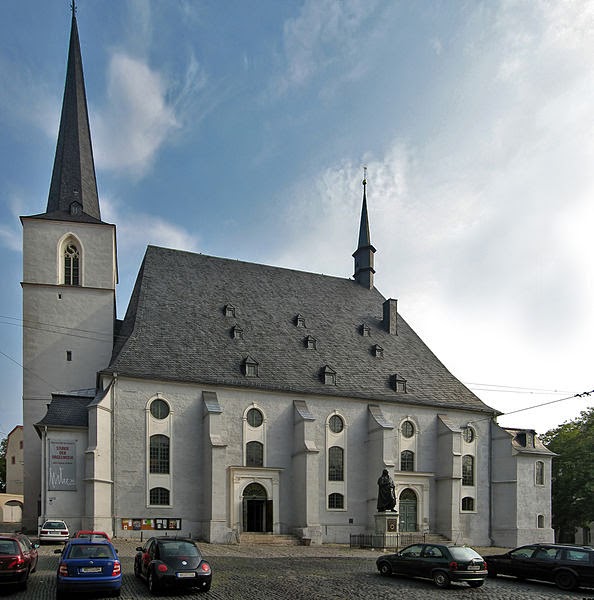
    The Goethe-Schiller-Denkmal at Theaterplatz is the most famous memorial in Weimar. It was made by Ernst Rietschel between 1852 and 1857 and is dedicated to Goethe and Schiller, the most important poets of German classical literature.

Weimar is connected by the Thuringian Railway to Leipzig in the east and to Frankfurt/Kassel in the west. Furthermore there are some regional railways to Gera via Jena and to Kranichfeld via Bad Berka. Today, there are long-distance trains to Frankfurt via Erfurt and Fulda and to Dresden via Leipzig and regional trains to Göttingen and Eisenach via Erfurt, to Halle via Naumburg, to Altenburg, Glauchau, Zwickau and Greiz via Jena and Gera and to Kranichfeld. When the new Erfurt–Leipzig/Halle high-speed railway will open (in 2015), Weimar will be disconnected from German long-distance train network. On the other hand, regional trains shall be strengthened to connect Weimar with ICE-stops in Erfurt, Halle and Leipzig.

In freight transport exists an intermodal terminal in Vieselbach (Güterverkehrszentrum/GVZ) with connection to rail and Autobahn, 15 km (9 mi) west of Weimar.

Weimar is located at the Bundesautobahn 4 (Frankfurt–Dresden). Furthermore, there are two federal streets to Erfurt and Jena (Bundesstraße 7) and to Rudolstadt and Kölleda (Bundesstraße 85) as well as some regional streets to Sömmerda, Oßmannstedt and Magdala. A bypass street around Weimar has been built in 2000s in the north and west, the eastern and southern continuation are in discussion, but not in definite planning because of some difficulties in routing.

By aviation

The Erfurt-Weimar Airport lies approximately 30 km (19 mi) west of Weimar. It was largely extended in 1990s, but anticipations did not fulfill so that there is only rare air traffic, mostly to Mediterranean holiday regions. Other flights are carried out via Frankfurt Airport, which can be reached in 3 h and prospective via Berlin Brandenburg Airport, which will open in 2014 and is accessible within 3 h.

By bike

Biking is getting more and more popular since the construction of quality cycle tracks began in the 1990s. For tourism serve the Ilm track and the Thuringian city string track (Radweg Thüringer Städtekette). Both connect points of tourist interest, the first along the Ilm valley from Thuringian Forest to Saale river and second near to medieval Via Regia from Eisenach via Gotha, Erfurt, Weimar and Jena to Altenburg. Additionally, there are some theme routes like the Goethe cycle track and the Feininger cycle track. For inner city every-day traffic exist some cycle lanes along several main streets. Bike renting is offered in city centre.

Bus service

For a small city, Weimar is well served by city bus routes, which also serve all of the annex towns and villages. An hourly bus route serves the Buchenwald Memorial and oldtimer buses go in city's historical centre. All bus routes are connected at Goethe Square in city centre, most run furthermore to the main station. Between 1899 and 1937 were trams in operation. Trolleybus service started in 1948 and was ceased in 1993.

Crete

$
0
0
Executive summary by darmansjah

Crete  is the largest and most populous of the Greek islands, the fifth-largest island in the Mediterranean Sea, and one of the thirteen administrative regions of Greece.The capital and the largest city of Crete is Heraklion. It forms a significant part of the economy and cultural heritage of Greecewhile retaining its own local cultural traits (such as its own poetry, and music). Crete was once the center of the Minoan civilization (c. 2700–1420 BC), which is currently regarded as the earliest recorded civilization in Europe.

The island has three significant airports, Nikos Kazantzakis at Heraklion, the Daskalogiannis airport at Chania and a smaller one in Sitia. The first two serve international routes, acting as the main gateways to the island for travellers. There is a long-standing plan to replace Heraklion airport with a completely new airport at Kastelli, where there is presently an air force base.

The island is well served by ferries, mostly from Athens, by ferry companies such as Minoan Lines and ANEK Lines.

Although the road network leads almost everywhere, there is a lack of modern highways, although this is gradually changing with the completion of the northern coastal spine highway.

Also, during the 1930s there was a narrow-gauge industrial railway in Heraklion, from Giofyros in the west side of the city to the port. There are now no railway lines on Crete.

Crete is one of the most popular holiday destinations in Greece. Fifteen percent of all arrivals in Greece come through the city of Heraklion (port and airport), while charter journeys to Heraklion last year made up 20% of all charter flights in Greece. Overall, more than two million tourists visited Crete last year,[when?] and this increase in tourism is reflected on the number of hotel beds, rising by 53% in the period between 1986 and 1991, when the rest of Greece saw increases of only 25%. Today, the island's tourism infrastructure caters to all tastes, including a very wide range of accommodation; the island's facilities take in large luxury hotels with their complete facilities, swimming pools, sports and recreation, smaller family-owned apartments, camping facilities and others. Visitors reach the island via two international airports in Heraklion and Chania and a smaller airport in Sitia (international charter and domestic flights starting May 2012) or by boat to the main ports of Heraklion, Chania, Rethimno, Agios Nikolaos and Sitia. Popular tourist attractions include the archaeological sites of the Minoan civilisation, the Venetian old city and port of Chania, the Venetian castle at Rethymno, the gorge of Samaria, the islands of Chrysi, Elafonisi, Gramvousa, and Spinalonga and the Palm Beach of Vai, which is the largest natural palm forest in Europe.


Patmos

$
0
0
Executive summary by darmansjah

Patmos is a small Greek island in the Aegean Sea. One of the northernmost islands of the Dodecanese complex, it has a population of 2,998 and an area of 34.05 km2 (13.15 sq mi). The highest point is Profitis Ilias, 269 metres (883 ft) above sea level. The Municipality of Patmos, which includes the offshore islands of Arkoi (pop. 44), Marathos (pop. 5), and several uninhabited islets, has a total population of 3,047 (2011 census)  and a combined land area of 45.039 square kilometres (17.390 sq mi). It is part of the Kalymnos regional unit.

Patmos' main communities are Chora (the capital city), and Skala, the only commercial port. Other settlements are Grikou and Kampos. The churches and communities on Patmos are of the Eastern Orthodox tradition. In 1999, the island's historic center Chora, along with the Monastery of Saint John the Theologian and the Cave of the Apocalypse, were declared World Heritage Sites by UNESCO. The monastery was founded by Saint Christodulos. Patmos is also home to the Patmian School, a notable Greek seminary.

Patmos is mentioned in the Bible Book of Revelation. The book's introduction states that its author, John, was on Patmos when he was given (and recorded) a vision from Jesus. Early Christian tradition identified this writer John of Patmos as John the Apostle, though some modern scholars are uncertain. As such, Patmos is a destination for Christian pilgrimage. Visitors can see the cave where John is said to have received his Revelation (the Cave of the Apocalypse), and several monasteries on the island are dedicated to Saint John.

Forbes in a 2009 research has named Patmos as Europe's Most Idyllic Place to live, due to the fact that "Patmos has evolved over the centuries but has not lost its air of quiet tranquility, which is one reason why people that know it return again and again."

Mykonos and Delos

$
0
0
Executive summary by darmansjah

The island of Delos , near Mykonos, near the centre of the Cyclades archipelago, is one of the most important mythological, historical and archaeological sites in Greece. The excavations in the island are among the most extensive in the Mediterranean; ongoing work takes place under the direction of the French School at Athens and many of the artifacts found are on display at the Archaeological Museum of Delos and the National Archaeological Museum of Athens.

Delos had a position as a holy sanctuary for a millennium before Olympian Greek mythology made it the birthplace of Apollo and Artemis. From its Sacred Harbour, the horizon shows the two conical mounds (image below) that have identified landscapes sacred to a goddess in other sites: one, retaining its pre-Greek name Mount Kynthos, is crowned with a sanctuary of Zeus.

Established as a culture center, Delos had an importance that its natural resources could never have offered. In this vein Leto, searching for a birthing-place for Artemis and Apollo, addressed the island:

Mykonos is a Greek island, part of the Cyclades, lying between Tinos, Syros, Paros and Naxos. The island spans an area of 85.5 square kilometres (33.0 sq mi) and rises to an elevation of 341 metres (1,119 feet) at its highest point. There are 10,134 inhabitants (2011 census) most of whom live in the largest town, Mykonos, which lies on the west coast. The town is also known as Chora (i.e. the Town in Greek, following the common practice in Greece when the name of the island itself is the same as the name of the principal town).

Mykonos' nickname is The island of the winds.[citation needed] Tourism is a major industry.

Santorini

$
0
0

Executive summary by darmansjah


Santorini  is an island in the southern Aegean Sea, about 200 km (120 mi) southeast of Greece's mainland. It is the largest island of a small, circular archipelago which bears the same name and is the remnant of a volcanic caldera. It forms the southernmost member of the Cyclades group of islands, with an area of approximately 73 km2 (28 sq mi) and a 2011 census population of 15,550. The municipality of Santorini comprises the inhabited islands of Santorini and Therasia and the uninhabited islands of Nea Kameni, Palaia Kameni, Aspronisi, and Christiana. The total land area is 90.623 km2 (34.990 sq mi). Santorini is part of the Thira regional unit.

Santorini is essentially what remains after an enormous volcanic explosion that destroyed the earliest settlements on a formerly single island, and created the current geological caldera. A giant central, rectangular lagoon, which measures about 12 by 7 km (7.5 by 4.3 mi), is surrounded by 300 m (980 ft) high, steep cliffs on three sides. The main island slopes downward to the Aegean Sea. On the fourth side, the lagoon is separated from the sea by another much smaller island called Therasia; the lagoon is connected to the sea in two places, in the northwest and southwest. The depth of the caldera, at 400m, makes it possible for all but the largest ships to anchor anywhere in the protected bay; there is also a newly built marina at Vlychada, on the southwestern coast. The island's principal port is Athinias. The capital, Fira, clings to the top of the cliff looking down on the lagoon. The volcanic rocks present from the prior eruptions feature olivine and have a small presence of hornblende.

It is the most active volcanic centre in the South Aegean Volcanic Arc, though what remains today is chiefly a water-filled caldera. The volcanic arc is approximately 500 km (310 mi) long and 20 to 40 km (12 to 25 mi) wide. The region first became volcanically active around 3–4 million years ago, though volcanism on Thera began around 2 million years ago with the extrusion of dacitic lavas from vents around the Akrotiri.

The island is the site of one of the largest volcanic eruptions in recorded history: the Minoan eruption (sometimes called the Thera eruption), which occurred some 3600 years ago at the height of the Minoan civilization. The eruption left a large caldera surrounded by volcanic ash deposits hundreds of metres deep and may have led indirectly to the collapse of the Minoan civilization on the island of Crete, 110 km (68 mi) to the south, through a gigantic tsunami. Another popular theory holds that the Thera eruption is the source of the legend of Atlantis.

The Monasteries of the Meteora

$
0
0
Executive summary by darmansjah

The Metéora  "middle of the sky", "suspended in the air" or "in the heavens above"— etymologically related to "Meteorite") is one of the largest and most important complexes of Eastern Orthodox monasteries in Greece, second only to Mount Athos. The six monasteries are built on natural sandstone rock pillars, at the northwestern edge of the Plain of Thessaly near the Pineios river and Pindus Mountains, in central Greece. The nearest town is Kalambaka. The Metéora is included on the UNESCO World Heritage List under criteria] I, II, IV, V and VII

The Holy Monastery of Great Meteoron - This is the largest of the monasteries located at Metéora. It was erected in the mid-14th century and was the subject of restoration and embellishment projects in 1483 and 1552. The building serves as the main museum for tourists. The Katholikon (main church), consecrated in honour of the Transfiguration of Jesus was erected in the middle of 14th century and 1387/88 and decorated in 1483 and 1552.


The Holy Monastery of Varlaam – The Holy Monastery of Varlaam is the second largest monastery in the Metéora complex. It was built in 1541 and embellished in 1548. A church, dedicated to All Saints, is in the Athonite type (cross-in-square with dome and choirs), with spacious exonarthex (lite) is surrounded by a dome. It was built in 1541/42 and decorated in 1548, while the exonarthex was decorated in 1566. The old refectory is used as a museum while north of the church is the parekklesion of the Three Bishops, built in 1627 and decorated in 1637.

The Holy Monastery of Rousanou/St. Barbara was founded in the middle of 16th century and decorated in 1560.


The Holy Monastery of St. Nicholas Anapausas, built in the 16th century, is a small church. It was decorated by the Cretan painter Theophanis Strelitzas, in 1527.

The Holy Monastery of St. Stephen is a small church built in the 16th century and decorated in 1545. This monastery rests on the plain rather than on a cliff. It was damaged by the Nazis during World War II who believed it was harboring insurgents and was abandoned. Nuns took it over and reconstructed it.


The Monastery of the Holy Trinity is on top of the cliffs. It was built in 1475 and was remodeled many times in 1684, 1689, 1692, 1741.

The Varlaam monastery on its rock pedestal.

The monastery Agiou Stephanou (Saint Stephen's) is inhabited by nuns only.

The Rousanou, the Nikolaos and the Grand Meteora monasteries.

The Grand Meteoro monastery.

The Holy Monastery of St. Nicholas Anapausas

Panorama of the Meteora valley

Panoramic view at Meteora valley

Panoramic view at monastery Roussanou


Rhodes

$
0
0
Executive summary by darmansjah

Rhodes is an island in Greece, located in the eastern Aegean Sea. It is the largest of the Dodecanese islands in terms of both land area and population, with a population of 115,490 (2011 census), and also the island group's historical capital. Administratively the island forms a separate municipality within the Rhodes regional unit, which is part of the South Aegean region. The principal town of the island and seat of the municipality is Rhodes. The city of Rhodes had 50,636 inhabitants in 2011. It is located northeast of Crete, southeast of Athens and just off the Anatolian coast of Turkey. Rhodes' nickname is The island of the Knights.

Historically, Rhodes was famous worldwide for the Colossus of Rhodes, one of the Seven Wonders of the Ancient World. The Medieval Old Town of the City of Rhodes has been declared a World Heritage Site. Today, it is one of the most popular tourist destinations in Europe.

Transportation

Diagoras Airport, arrivals terminal.

Rhodes has three airports but only one is public. Diagoras Airport, one of the biggest in Greece, is the main entrance/exit point for both locals and tourists. The island is well connected with other major Greek cities and islands as well as with major European capitals and cities via charter flights.

Rhodes International Airport, "Diagoras": public airport, 14 km (9 mi) southwest of Rhodes City, third in international passenger volume and fourth in total passenger volume in Greece.

Rhodes Maritsa Airport: closed to public, near Maritsa village. Built in 1938 by the Italians, it was the first airport of the island and was the public airport until 1977. Nowadays, it serves the Hellenic Air Force and is sometimes used for car races.

Kalathos Airfield: inoperative, 7 km (4 mi) north of Lindos. Built by the Italians during World War II, was called Aeroporto di Gadurrà. Today only the runway is visible.

Kattavia Airstrip, located in the south of the island it was an emergency airstrip built by the Italians during World War II. Today it is abandoned.

Two pilot schools offer aviation services (small plane rental and island hopping).

"MS Thomson Majesty" at the harbour of Rhodes.

The Kameiros Skala Dock.

Rhodes has five ports, three of them in Rhodes City, one in the west coast near Kamiros and one in east coast near Lardos.

Central Port: located in the city of Rhodes serves exclusively international traffic consisting of scheduled services to/from Turkey, cruise ships and yachts. Since Summer 2012, the port is also a homeport for Costa Cruises during the summer period.

Kolona Port: opposite and north of the central port, serves intra-Dodecanese traffic and all sizes yachts.

Akandia Port: the new port of the island, south and next to the central port, being built since the 1960s, for domestic, cargo and general purpose traffic. No land facilities exist although the municipality is in the process of erecting a passenger terminal.

Kamiros Skala Dock: 30 km (19 mi) south west of the city near Ancient Kamiros ruins serves mainly the island of Halki

Lardos Dock: formerly servicing local industries, now under development as an alternative port for times when the central port is inaccessible due to weather conditions. It is situated in a rocky shore near the village of Lardos in south east Rhodes.

Road network

The road network of the island is mostly paved. There are four major arteries:

Rhodes-Kamiros Province Avenue: Two lane, runs through the west coast north to south and connects Rhodes City with Diagoras Airport and Kamiros.

Rhodes-Lindos National Avenue (Greek National Road 95): Four and two lane, runs mainly inland north to south and connects Rhodes City with Lindos. Part from Rhodes Town until Kolympia is now 4 lanes, the rest until Lindos is 2 lanes.

Rhodes-Kallithea Province Avenue: Two lanes, runs through the east coast north to south and connects Rhodes City with Faliraki Resort.

Tsairi-Airport National Avenue: Four and two lane, runs inland east to west and connects the east coast with the west and the airport.

Lindos-Katavia Province Avenue: Two lane, begins just before Lindos and though villages and resorts leads to Katavia village, the southernmost of the island, from where a further deviation leads to Prasonissi.     

Rhodes Town Ring Road: First part beginning from the new marina and ending to Rhodes-Kallithea province avenue is now almost complete as a four lane expressway. Traffic lights will be installed till the end of 2013 which will mark the completion of the road making left turns available.

Future roads:

Further widening of E-95 from Kolympia to Lindos. This is to be four lane with a jersey barrier in the middle. It is still unknown when constructions will begin and most importantly end.

Plans also exist for a new four lane express road connecting Rhodes Town with Diagoras Airport that is intended to relieve congestion on the coastal west avenue.

Bus

Bus services are handled by two operators:
RODA: Rhodes City company that also services suburban areas (Faliraki, Ialysos, Kremasti, Airport, Pastida, Maritsa, Paradeisi) and the west coast of the island
KTEL: State-owned buses that serve villages and resorts in the east coast of the island

Cars and motorbikes

Families in Rhodes often own more than one car, along with a motorbike. Traffic jams are common particularly in the summer months. The island is served by 450 taxis.

Symi

$
0
0
Executive summary by darmansjah

It is mountainous and includes the harbor town of Symi and its adjacent upper town Ano Symi, as well as several smaller localities, beaches, and areas of significance in history and mythology. Symi is part of the Rhodes regional unit.

The shipbuilding and sponge industries were substantial on the island and, while at their peak near the end of the 19th century, the population reached 22,500. Symi's main industry is now tourism and the population has declined to 2,500

The Acropolis

$
0
0
Executive summary by darmansjah

The Acropolis of Athens  is an ancient citadel located on a high rocky outcrop above the city of Athens and containing the remains of several ancient buildings of great architectural and historic significance, the most famous being the Parthenon. The word acropolis comes from the Greek words (akron, "edge, extremity") and  (polis, "city"). Although there are many other acropoleis in Greece, the significance of the Acropolis of Athens is such that it is commonly known as "The Acropolis" without qualification.

While there is evidence that the hill was inhabited as far back as the fourth millennium BC, it was Pericles (c. 495 – 429 BC) in the fifth century BC who coordinated the construction of the site's most important buildings including the Parthenon, the Propylaia, the Erechtheion and the temple of Athena Nike. The Parthenon and the other buildings were seriously damaged during the 1687 siege by the Venetians in the Morean War when the Parthenon was being used for gunpowder storage and was hit by a cannonball.

The Acropolis was formally proclaimed as the preeminent monument on the European Cultural Heritage list of monuments on 26 March 2007

National Archaeology Museum

$
0
0
Executive summary by darmansjah

The National Archaeological Museum  in Athens houses some of the most important artifacts from a variety of archaeological locations around Greece from prehistory to late antiquity. It is considered one of the great museums in the world and contains the richest collection of artifacts from Greek antiquity worldwide. It is situated in the Exarcheia area in central Athens between Epirus Street, Bouboulinas Street and Tositsas Street while its entrance is on the Patission Street adjacent to the historical building of the Athens Polytechnic university.

Delphi

$
0
0
Executive summary by darmansjah

Delphi  is both an archaeological site and a modern town in Greece on the south-western spur of Mount Parnassus in the valley of Phocis. In myths dating to the classical period of Ancient Greece (510-323 BC), the site of Delphi was believed to be determined by Zeus when he sought to find the centre of his "Grandmother Earth" ( Gaea). He sent two eagles flying from the eastern and western extremities, and the path of the eagles crossed over Delphi where the omphalos, or navel of Gaia was found.

Earlier myths include traditions that Pythia, or the Delphic oracle, already was the site of an important oracle in the pre-classical Greek world (as early as 1400 BC) and, rededicated, served as the major site during classical times for the worship of the god Apollo after he slew Python, "a dragon" who lived there and protected the navel of the Earth. "Python" (derived from the verb pythein, "to rot") is claimed by some to be the original name of the site in recognition of Python which Apollo defeated. The Homeric Hymn to Delphic Apollo recalled that the ancient name of this site had been Krisa. Others relate that it was named Pytho and that Pythia, the priestess serving as the oracle, was chosen from their ranks by a group of priestesses who officiated at the temple.

Apollo's sacred precinct in Delphi was a panhellenic sanctuary, where every four years, starting in 586 BC  athletes from all over the Greek world competed in the Pythian Games, one of the four panhellenic (or stephanitic) games, precursors of the Modern Olympics. The victors at Delphi were presented with a laurel crown (stephanos) which was ceremonially cut from a tree by a boy who re-enacted the slaying of the Python. Delphi was set apart from the other games sites because it hosted the mousikos agon, musical competitions.
 
These Pythian Games rank second among the four stephanitic games chronologically and based on importance. These games, though, were different from the games at Olympia in that they were not of such vast importance to the city of Delphi as the games at Olympia were to the area surrounding Olympia. Delphi would have been a renowned city whether or not it hosted these games; it had other attractions that led to it being labeled the "omphalos" (navel) of the earth, in other words, the center of the world.

In the inner hestia ("hearth") of the Temple of Apollo, an eternal flame burned. After the battle of Plataea, the Greek cities extinguished their fires and brought new fire from the hearth of Greece, at Delphi; in the foundation stories of several Greek colonies, the founding colonists were first dedicated at Delphi.

Epidaurus

$
0
0
Executive summary by darmansjah

Epidaurus  was a small city (polis) in ancient Greece, at the Saronic Gulf. Two modern towns bear the name Epidauros : Palaia Epidauros and Nea Epidauros. Since 2010 they belong to the new municipality of Epidaurus, part of the regional unit of Argolis. The seat of the municipality is the town Asklipieion.
Viewing all 1406 articles
Browse latest View live


Latest Images