↧
America's Best Adventures Trails


↧
Malawi
Africa’s liquid asset
executive summary by darmansjah
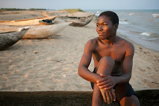
Locals call it the “Lake of Stars,” and it’s easy to see why. After nightfall, paraffin lamps illuminate Lake Malawi with a constellation of firefly-like flickers; fishermen in dugout canoes work the glassy waters as they have since before the era of the Maravi kingdom.
Deep and clear, the teal lake—Africa’s third largest—glimmers in the Great Rift Valley. Bordering Tanzania, Mozambique, and Zambia, Malawiis an increasingly steady presence within a dynamic continent. Last year, a political transition introduced the world to Joyce Banda, a progressive new president and the second female chief of state in sub-Saharan Africa. More than a domestic shift, this turning point presents an invitation to explore Africa’s best kept secret.
“When you make friends with a Malawian, they watch out for you,” says Moses Mphatso Kaufulu, a blogger from the historic British capital of Zomba. “The depth of African experience rests on friendship—this is what makes my country second to none in the world.”
Where better to befriend a local than by the lake? Swimming boys laugh as a kaleidoscope of brightly colored fish glitter to the surface. The only high-rise in sight is a jumble of sunbleached boulders. Malawi offers much more than serene lakes. Dusty roads connect towns, and mountains give way to plains of green maize punctuated by baobab trees. But the nation’s heart is a watery realm where waves lap the sand, leaving streaks of silt. —Andrew Evans
Travel Tips
When to Go: For lake and big game safaris, go in the dry seasons, April/May and October/November. Between January and March more than 200 species of orchids bloom in Nyika National Park, making this prime time for orchid lovers and bird-watchers.
Where to Stay: Guests at the rustic, six-room Red Zebra Lodge at Kambiri Point can join underwater safaris to view Lake Malawi’s diverse aquatic life, including the intensely colorful African cichlid fish. Remote Chiofu Camp, accessible only by a 3.5-hour boat ride east from Kambiri Point, offers bare-bones beach camping in light tents secured under the trees.
Cultural Tips: Comfortable, casual dress is the norm, but reserve beachwear (tank tops, bathing suits, short dresses, and shorts) for vacation resorts.
What to Buy: Handcrafted baskets, intricate wood carvings, and Dedza Pottery including hand-painted tableware and figurines depicting Malawian life.
In-Country Travel Tip: Foreign currency is widely accepted. ATMs dispensing local currency are located in Lilongwe, Blantyre, and Mzuzu.
↧
↧
Madeira Island

Executive summary by darmansjah
The island of Madeira is at the top of a massive shield volcano that rises about 6 km (3.7 mi) from the floor of the Atlantic Ocean, on the Tore underwater mountain range. The volcano formed atop an east-west rift in the oceanic crust along the African Plate, beginning during the Miocene epoch over 5 million years ago, continuing into the Pleistocene until about 700,000 years ago. This was followed by extensive erosion, producing two large amphitheatres open to south in the central part of the island. Volcanic activity later resumed, producing scoria cones and lava flows atop the older eroded shield. The most recent volcanic eruptions were on the west-central part of the island only 6,500 years ago, creating more cinder cones and lava flows.
 Madeira Island represents 93% of the archipelago's area, with 90% of the landmass above 500 m. It is the largest island of the group with an area of 741 km2 (286 sq mi), a length of 57 km (35 mi) (from Ponte de São Lourenço to Ponte do Pargo), while approximately 22 km (14 mi) at its widest point (from Ponte da Cruz to Ponte São Jorge), with a coastline of 150 km (93.21 mi). It has a mountain ridge that extends along the centre of the island, reaching 1862 meters (6,107 ft) at its highest point (Pico Ruivo), while much lower (below 200 meters) along its eastern extent. The primitive volcanic foci responsible for the central mountainous area, consisted of the peaks: Ruivo (1862 meter), Torres (1851 meter), Areeiro (1818 meter), Cidrão (1802 meter), Cedro (1759 meter), Casado (1725 meter), Grande (1657 meter), Ferreiro (1582 meter). At the end of this eruptive phase, an island circled by reefs was formed, its marine vestiges are evident in a calcareous layer in the area of Lameiros, in São Vicente (which was later explored for calcium oxide production). Sea cliffs, such as Cabo Girão, valleys and ravines extend from this central spine, making the interior generally inaccessible. Daily life has concentrated in the many villages at the mouths of the ravines, through which the heavy rains of autumn and winter usually travel to the sea. A long, narrow, and comparatively low rocky promontory forms (Paul da Serra) the western extremity of the island, on which lies a tract of calcareous sand known (1300-1500 meter). It is a fossil bed, that contains shells and numerous bodies resembling the roots of trees, probably produced by infiltration.
The Base Volcanic Complex was formed during the Miocene period from submarine and sub-aerial eruptions in the central part of the island, and is associated with some of the deeper valleys (São Vicente, Boaventura, Socorridos). The complex extends to the east into the (Porto da Cruz and Machico) ravines until Ponta de São Lourenço and consists of accumulated block pyroclasts, lapilli and ash, layered with basaltic lava. The volcanic material is essentially effusive, of non-viscous compact basalts; the lava formed flows that were not dense which covered the topography and substrata. These first flows were extensive, occupying a large part of the plateau, filling many of the valleys and ending at the sea. More recent episodes were confined into the valley of the São Vicente, Seixal and Porto Moniz ravines. The basaltic flows correspond to the last period of volcanic activity on Madeira (around 500,000-200,000 of years). The flows were boxed into the valleys, and fossilised, sometimes, such as in the valley of São Vicente, forming morphological terraces. The island is covered in faults, and easily identifiable in the area around Ribeira Brava, near Encumeada. The spatial distribution of these faults is varied and their align is also diverse, although it is common to encounter some faults from west-northwest to east-south-southeast to northwest to southeast (coincident with the direction of some volcanic cones). Between many of pyroclastic cliffs, there exists a great variability in materials, from large blocks to fine ash, and an intermediary layer referred to locally as feijoco, or lapilli, of a consistency that is more porous. The material is normally dark to black rocks, yellow and reddish materials, and is used in some construction for their refractive characteristics (as well as used in the construction of blast ovens).

The Central Massif which occupies the central region of the island, consists of explosive material (large blocks, lapilli and ash) and deposited chaotically around volcanic centres of the eruptions, but today mostly hidden and unrecognisable. This massif is crossed by several dense faults, basaltic and trachyte, oriented in many directions, converging on Pico Ruivo. The peak which includes many dykes, has resisted erosion, in contrast to many of the surrounding deposits; the weak cohesion of pyroclastic materials permitted the easy carving of the terrain in this area, constituting the morphology of many of the ravines: Brava, Socorridos, Machico, São Vicente, Porco (Boaventura) and Faial.

The Paul da Serra Massif corresponds to a similar structural platform of basaltic flows oriented towards the southwest.
Climate
Madeira has been classified as a Mediterranean climate (Köppen climate classification: Csa/Csb), but based on differences in sun exposure, humidity, and annual mean temperature there are clear variations between north- and south-facing regions, as well as between some islands. Other microclimates are expected to exist, from the constantly humid wettest points of the mountains, to the desert and arid Selvagens islands. The islands are strongly influenced by the Gulf Stream and Canary Current, giving mild year-round temperatures; according to the Instituto de Meteorologia or IM the average annual temperature at Funchal weather station is 19.6 °C (67.3 °F) for the 1980-2010 period. For the 1960-1990 period, IM published an article, showing that some regions in the South Coastline surpass 20 °C (68 °F) in annual average. Porto Santo has at least one weather station with a semiarid climate.

Drought conditions coupled with hot and windy weather in summer have caused numerous wildfires in recent years. The largest of the fires in August, 2010 burned through 95 percent of the Funchal Ecological Park, a 1,000-hectare preserve set aside to restore native vegetation to the island. In July, 2012 Madeira was suffering from severe drought and wildfires began burning on July 18, in the midst of temperatures up to 40 degrees Celsius (more than 100 degrees Fahrenheit) and high winds. By July 20, fires had spread to the nearby island of Porto Santo, and firefighters were sent from mainland Portugal to contain the multiple blazes.

In August, 2013 a hospital and some homes were evacuated as a wildfire approached Funchal. A number of homes were destroyed when the fire hit Monte, a suburb of Funchal.
The Macaronesia region harbours an important floral diversity. In fact, the archipelago's forest composition and maturity are quite similar to the forests found in the Tertiary period that covered Southern Europe and Northern Africa millions of years ago. The great biodiversity of Madeira is phytogeographically linked to the Mediterranean region, Africa, America and Australia, and interest in this phytogeography has been increasing in recent years due to the discovery of some epiphytic bryophyte species with non-adjacent distribution.

Madeira also has many endemic species of fauna – mostly invertebrates which include the extremely rare Madeiran Large White but also some vertebrates such as the native bat, some lizards species, and some birds as already mentioned. The biggest tarantula of Europe is found on Desertas islands of Madeira and can be as wide as a man's hand. These islands have more than 250 species of land molluscs (snails and slugs), some with very unusual shell shape and colours, most of which are endemic and vulnerable.
Madeira has three endemic bird species: Zino's Petrel, the Trocaz Pigeon and the Madeira Firecrest, while the Madeiran Chaffinch is an endemic subspecies. It is also important for breeding seabirds, including the Madeiran Storm-petrel, North Atlantic Little Shearwater and Cory's Shearwater.

In the south, there is very little left of the indigenous subtropical rainforest which once covered the whole island (the original settlers set fire to the island to clear the land for farming) and gave it the name it now bears (Madeira means "wood" in Portuguese). However, in the north, the valleys contain native trees of fine growth. These "laurisilva" forests, called lauraceas madeirense, notably the forests on the northern slopes of Madeira Island, are designated as a World Heritage Site by UNESCO. The critically endangered vine Jasminum azoricum is one of the plant species that is endemic to Madeira.
Levadas
 The island of Madeira is wet in the northwest but dry in the southeast. In the 16th century the Portuguese started building levadas or aqueducts to carry water to the agricultural regions in the south. The most recent were built in the 1940s. Madeira is very mountainous, and building the levadas was difficult and often sentenced criminals or slaves were used. Many are cut into the sides of mountains, and it was also necessary to dig 25 miles (40 km) of tunnels, some of which are still accessible.
Today the levadas not only supply water to the southern parts of the island but provide hydro-electric power. There are over 1,350 miles (2,170 km) of levadas and they provide a remarkable network of walking paths. Some provide easy and relaxing walks through beautiful countryside, but others are narrow, crumbling ledges where a slip could result in serious injury or death.
 Two of the most popular levadas to hike are the Levada do Caldeirão Verde and the Levada do Caldeirão do Inferno which should not be attempted by hikers prone to vertigo or without torches and helmets. The Levada do Caniçal is a much easier walk, running 7.1 miles (11.4 km) from Maroços to the Caniçal Tunnel. It is known as the mimosa levada because mimosa trees are found all along the route.
 Tourism is an important sector in the region's economy since it contributes 20%[citation needed] to the region's GDP, providing support throughout the year for commercial, transport and other activities and constituting a significant market for local products. The share in Gross Value Added of hotels and restaurants (9%) also highlights this phenomenon. The island of Porto Santo, with its 9 km (5.6 mi) long beach and its climate, is entirely devoted to tourism. Over the past decade it has recorded a substantial increase in its hotel accommodation capacity.

Development in Madeira is considered to have future potential since the necessary infrastructure has been established and adequate investment incentives have been introduced for expanding its hotel and catering structure in a controlled manner. Nature conservation is seen as important because it is a major draw for tourists to Madeira.
Visitors are mainly from the European Union, with German, British, Scandinavian and Portuguese tourists providing the main contingents. The average annual occupancy rate was 60.3% in 2008, reaching its maximum in March and April, when it exceeds 70%.
Transport in Madeira
European Union citizens of the Schengen Treaty area can enter the islands freely, while those from other regions need identification.
 There were in 2009, 7,105 legal immigrants living in Madeira Islands. They come mostly from Brazil (1.300), the UK (912), Venezuela (732) and Ukraine (682), according to SEF.
The Islands have two airports, Funchal Airport on the Island of Madeira and the other in the island of Porto Santo. Flights to the islands are mostly made from Lisbon and Porto, but there are also direct flights from other major European cities and other countries, like Brazil, Venezuela, and South Africa.
Culture
 Folklore music in Madeira is widespread and mainly uses local musical instruments such as the machete, rajao, brinquinho and cavaquinho, which are used in traditional folkloric dances like the bailinho da Madeira.
 Emigrants from Madeira also influenced the creation of new musical instruments. In the 1880s, the ukulele was created, based on two small guitar-like instruments of Madeiran origin, the cavaquinho and the rajao. The ukulele was introduced to the Hawaiian Islands by Portuguese immigrants from Madeira and Cape Verde. Three immigrants in particular, Madeiran cabinet makers Manuel Nunes, José do Espírito Santo, and Augusto Dias, are generally credited as the first ukulele makers. Two weeks after they disembarked from the SS Ravenscrag in late August 1879, the Hawaiian Gazette reported that "Madeira Islanders recently arrived here, have been delighting the people with nightly street concerts.
Due to the geographic situation of Madeira, the island enjoys an abundance of fish of various kinds. The species that are consumed the most are Espada (Black scabbardfish), Blue Fin Tuna, White Marlin, Blue Marlin, Albacore, Bigeye Tuna, Wahoo, Spearfish, skipjack tuna and many others are found in the local dishes as they are found up and down the coast of Madeira. Espada is often served with banana. Bacalhau is also popular just like in Portugal.

There are many meat dishes on Madeira, one of the most popular being espetada. Espetada is traditionally made of large chunks of beef rubbed in garlic, salt and bay leaf and marinated for 4 to 6 hours in Madeira wine, red wine vinegar and olive oil then skewered onto a bay laurel stick and left to grill over smouldering wood chips. These are so integral a part of traditional eating habits that a special iron stand is available with a T-shaped end, each branch of the "T" having a slot in the middle to hold a brochette (espete in Portuguese); a small plate is then placed underneath to collect the juices. The brochettes are very long and have a V-shaped blade in order to pierce the meat more easily. It is usually accompanied with the local bread called bolo do caco.

Other popular dishes in Madeira include açorda, feijoada, carne de vinha d'alhos.
Traditional pastries in Madeira usually contain local ingredients, one of the most common being mel de cana, literally "sugarcane honey" (molasses). The traditional cake of Madeira is called Bolo de Mel, which translates as (Sugarcane) "Honey Cake" and according to custom, is never cut with a knife, but broken into pieces by hand. It is a rich and heavy cake. The cake commonly well known as "Madeira Cake" in England also finds its naming roots in the Island of Madeira.
Malasadas are a Madeiran creation which were taken around the world by emigrants to places such as Hawaii. In Madeira, Malasadas are mainly consumed during the Carnival of Madeira. Pastéis de nata, as in the rest of Portugal, are also very popular.
Beverages
 Madeira is a fortified wine, produced in the Madeira Islands; varieties may be sweet or dry. It has a history dating back to the Age of Exploration when Madeira was a standard port of call for ships heading to the New World or East Indies. To prevent the wine from spoiling, neutral grape spirits were added. However, wine producers of Madeira discovered, when an unsold shipment of wine returned to the islands after a round trip, that the flavour of the wine had been transformed by exposure to heat and movement. Today, Madeira is noted for its unique winemaking process which involves heating the wine and deliberately exposing the wine to some levels of oxidation.[65] Most countries limit the use of the term Madeira to those wines that come from the Madeira Islands, to which the European Union grants Protected Designation of Origin (PDO) status.
A local beer called Coral is produced by the Madeira Brewery, which dates from 1872. Other Portuguese beers are also popular on Madeira, but to a lesser extent.
Other alcoholic drinks are also popular in Madeira, such as the locally created Poncha, Niquita, Pé de Cabra, Aniz, as well as Portuguese drinks such as Macieira Brandy, Licor Beirão.
Laranjada is a type of carbonated soft drink with an orange flavour (the Portuguese word for orange is laranja), which is 14 years older than Coca-Cola. Launched in 1872 it was the first soft drink to be produced in Portugal and remains very popular to the present day. Brisa drinks are also very popular and come in a range of flavours.
 Here is also a huge coffee culture in Madeira. Like in mainland Portugal, popular coffee-based drinks include Garoto, Galão, Bica, Café com Cheirinho, Mazagran, Chinesa and many more.
promote Madeiran gastronomy worldwide, every November the Madeira Gourmet Festival is held. The festival brings international chefs to the island, mixing their know-how with local young chefs and preparing new recipes using Madeiran traditional products, like Madeira wine, local fish and other products.
↧
Marseille
France’s new capital of culture

executive summary by darmansjah
On a once derelict jetty, opposite the stone ramparts of 17th-century Fort St. Jean, a new glass-and-steel building shimmers behind a lacy spider’s-web facade of finely cast concrete. Poised between lapis sea and Marseille’s sun-drenched hills, the National Museum of European and Mediterranean Civilizations (MuCEM) stands at the entrance to the Vieux-Port, the city’s historic heart. And when it opens in May 2013, MuCEM will be a bold symbol of Marseille’s reemergence as a flourishing pan-Mediterranean hub.
Cities may rise and fall, but the great ones—and Marseille is among them—always rise again. Founded by ancient Greeks, France’s second largest city was already 500 years old and a bubbling stew of many cultures when Caesar laid siege in 49 B.C. A 20th-century wave of immigrants from Algeria and some other former French colonies led to Marseille’s modern reputation as a city far removed ethnically and psychologically from the rest of France. Despite recent headlines about drug-related crime, Marseille still stands tall as a world-class city.
These days Marseille has every right to act the cagou (slang for a show-off) as it and the surrounding Provence region assume the role of 2013 European Capital of Culture. “There is a new energy in the city, especially in music, theater, and museums,” says MuCEM director Bruno Suzzarelli. Young, multiethnic crowds gather for cutting-edge happenings at La Friche la Belle de Mai, a tobacco factory turned art and performance center. Major renovations have polished up many of the city’s 20-plus museums, including the Musée Cantini, whose trove of Picassos and Mirós is housed in an elegant 1694 town house. For all the new energy, Marseille’s old pleasures remain as alluring as ever: a stroll along the narrow lanes of the Panier Quarter, the lusty aromas of a good bouillabaisse, a boat ride into the fjordlike inlets called calanques. It’s no wonder that visitors are becoming fadas (big fans) of France’s southern gateway. —Christopher Hall
Travel Tips
When to Go: June-August for beaches, April-May and September-October for comfortable temperatures and lighter tourist traffic.
Where to Stay: Walk to the Vieux Port from the sleek and affordable Mama Shelter Marseille or see the boats from your private terrace at the luxurious Sofitel Marseille Vieux Port.
How to Get Around: The Régie des Transports de Marseille public transportation network includes metro, bus, and tramway lines. Consider a tourist City Pass for one or two days’ travel, museum admissions, and tours. March-September, a batobus(water shuttle) runs between the Vieux Port and Pointe Rouge. Kitschy, blue-and-white tourist trains wind through the streets of the oldest districts.
Where to Eat or Drink: Bouillabaisse is the homegrown culinary art form. Try Le Miramar in the Vieux Port or Chez Fonfon or L’Epuisette in Vallon des Auffes.
What to Buy: Wander through the maze of indoor and outdoor stalls at the Marché aux Puces and the daily Prado Market. Shop for santons(clay crèche figures), olive and lavender soap, olive oil, navettes(small, rowboat-shaped orange or lemon cookies), and pétanque balls.
What to Watch Before You Go: The Fanny Trilogy (Marius, Fanny, Cesar), 1948 (DVD 2004). Beloved 1930s French films (English subtitles), adaptations of the plays by Marseille’s preeminent writer, Marcel Pagnol, are considered national cultural treasures.
Fun Fact: France’s newest national park, Parc National des Calanques, is located on the outskirts of Marseille. Created in April 2012, the land (lagoons, cliffs, beaches) and sea (dolphins, turtles, seabirds) preserve is accessible only by foot or boat.
↧
Memphis
Tennessee’s fast track

executive summary by darmansjah
It’s easy to forget about Memphis, a mid-size American city wedged into the southwest corner of Tennessee. Our collective memory of Memphis seems frozen in the mid-20th century: Elvis and Graceland, B. B. King and Beale Street, Martin Luther King, Jr., and his “Mountaintop” speech—the last he’d give before his assassination on the balcony of Memphis’s Lorraine Motel in 1968.
Certain aspects of Memphis’s past stifled the city for decades, snuffing the spirits of residents and scaring away visitors. But there’s something newly electric in the air.
The Stax Museum of American Soul Music, located on the grounds of the famous Stax Records, is at the forefront of that revival. The museum, along with its Stax Music Academy and the Soulsville Charter School, celebrates its tenth anniversary in 2013 with concerts, parties, and Stax to the Max, a huge outdoor music festival. It’s far from a solo act.
All around Memphis, locals are pursuing grassroots projects more often associated with Brooklyn or the Bay Area. The nonprofit Project Green Fork has certified dozens of Memphis restaurants as sustainable, linking chefs with farmers and stimulating a vibrant local food community along the way. Running the culinary gamut from down-home Central BBQ to upscale Andrew Michael Italian Kitchen, the eateries are held to admirably high standards in sourcing and sustainability.
And there’s no better setting for a grassroots revival. Memphis claims one of the largest urban parks in the country: the 4,500-acre Shelby Farms Park, with 6.5 miles of urban trails and a working farm. The Office of Sustainability supports the city’s plans to expand the existing 35 miles of bike lanes to 85 miles and to build a greenway that will link Memphis with cities in Arkansas and Mississippi. “We get to innovate,” says city administrator Paul Young. It’s a fitting description for Memphis. —Julie Schwietert Collazo
Travel Tips

When to Go: Memphis in May International Festival is a monthlong arts, culture, and culinary celebration that includes the Beale Street Music Festival (May 3-5, 2013) and the World Championship Barbecue Cooking Contest (May 16-18, 2013).
Where to Stay: The traditional Peabody Memphis and contemporary Madison Hotel offer easy access to Beale Street and other downtown landmarks. Visitors flock to the Peabody’s Grand Lobby at 11 a.m. and 5 p.m. daily to watch the hotel’s resident ducks take a dip in the lobby's travertine fountain. The vibe is decidedly more subdued at the luxurious Madison with its intimate rooftop garden.
How to Get Around: Memphis Area Transit Authority (MATA) vintage trolley cars cover three tourist-friendly routes: Main Street, Riverfront Loop, and Madison Avenue. Buy a trolley pass (daily $3.50, three-day $9) to hop on and off at destinations like the National Civil Rights Museum, River Walk, and FedEx Forum.
Where to Eat or Drink: Share a slab of Memphis-style ribs at Central BBQ. Order half wet (smoked with a secret blend of spices and BBQ sauce) and half dry (spices only) with a side of homemade potato chips.
What to Read Before You Go:The Firm (1991) or The Client (1993), by John Grisham. Both set mainly in Memphis, these legal thrillers evoke the sultry, soulful—and grittier—side of the Bluff City.
Fun Fact: Memphis-based Stax Records (named for the first two letters of founder Jim Stewart’s and his investor-sister Estelle Axton’s last names) cranked out more than 800 soul and R&B singles and close to 300 albums during the '60s and '70s.
Helpful Links: Memphis Convention and Visitors Bureau
↧
↧
Messinia Region, Greece

executive summary by darmansjah
Widely known for its Kalamata olives—Messinia produces about 55,000 tons of mainly cold-pressed extra virgin olive oil annually—this road-less-trampled region on the southwest Peloponnesian coast features numerous World Heritage List archaeological sites, including Olympia, Mystras, and the Temple of Apollo Epicurius at Bassae.
Sun-drenched hills and valleys are dotted with stone houses, vaulted tombs from the Mycenaean era, Byzantine churches, and medieval castles (such as the castle of Methoni, above). Retreat to secluded bays, remote beaches, and protected lagoons, including Gialova, Greece’s southernmost major wetland and home to more than 270 bird species.
The latest chapter in Messinia’s 4,500-year history is being crafted by international shipping magnate Captain Vassilis Constantakopoulos, the visionary behind Costa Navarino, an energy-conscious resort that aims to be powered entirely by renewable resources. The luxury destination’s Navarino Dunes on the Ionian Sea opened in 2010. Initial sustainable elements include “living roofs” planted with native fauna and the world’s first large-scale geothermal heating and cooling installed beneath a golf course.
↧
Montauk on My Mind
Nostalgia inspires a road trip along the vineyards and beach towns of eastern Long Island, original text by Janelle Nanos

executive summary bydarmansjah
ON A MAP, the east end of Long Island, N.Y., looks like the gaping jaws of a crocodile. I’m at the back of the animal’s throat, driving northeast on County Road 105, when I see the mouth opening wide in front of me. Here the reptile’s smile spreads around the Great Peconic Bay. “Head north, head north,” I tell my husband, Tim, and the suburban sprawl so synonymous with central Long Island give way to farmland. Hand-painted roadside signs advertise fresh eggs, raw milk, lavender bouquets. I roll down the windows, slide back the sunroof, and crank up the radio. My hand surfs up and down on the wind. I breathe deeply, inhaling salty air and a bit of dust kicked up from the road. “I love it out here,” I say, as Tim laughs. “I know,” he says. “You’re geeking out like a little kid.”

I was a kid when I first came here, out where the highways narrow to two-lane roads, where the houses grew larger, then small again, all the way out to ‘the end’, as the locals call it. Montauk. My extended family gathered to camp each summer at Hither Hills, an oceanfront state park outside Montauk. I learned how to ride a bike, fell in love with stargazing, and, most nights, collapsed into my sleeping bag after hours of wave jumping in the Atlantic. Then, when I was 11, my mom and dad split up. Family vacations became casualties of an ongoing war. Neither parent ever took my brother or me back. When I met tim, I confided that Montauk was ‘my happy place.’ After a dozen years together, he and I have finally booked a campsite at Hither Hills. But before we ferry to Montauk, we need provisions from the island’s agrarian North Fork.
FINALLY I SPOT the large green and white house of Briermere Farms at the end of the road. “That’s it, stop there,” I tell Tim, pointing. “And get the cooler ready.” We fill our basket with plump berries, corn, tomatoes, and – the crown of our haul – one of the farm’s famous pies, a strawberry or rhubarb still warm from the oven.

As we drive east, rows of grapevines stretch out, their arms entwined like lines of family members gleefully dancing the “Hava Nagila” – almost as if the land itself is celebrating the North Fork’s evolution over the past four decades from potato to wine country.
“Good wine needs cheese,” says tim, flashing a cheesy smile, and we turn right on Love Lane into the tiny thumbprint of a town called Mattituck. Inside the sunny Village Cheese Shop,. A cherub-faced cheesemonger approaches us. “Anything in particular in mind?” asks the teen, and upon hearing our plans to visit some nearby vineyards, he reaches into the fridge-pilled with some 300 varieties-and fishes out a Reading raclette from Vermont. While carving off a sliver, he explains how it’ll keep in the warm weather. The cheese is pungent and smooth; Tim nods his approval.
Another few minutes on the road brings us to Shinn Estate Vineyards. Thwack-thwack, thwack-thwack. I hop out of the car to discover a windmill spinning frantically-and loudly-overhead. We slip into the recesses of the rustic tasting room, in a 125-year-old barn. A border collie immediately plops his head in Tim’s lap.

Owner and winemaker Barbara Shinn comes over to check on her sidekicks, Panda, and offers us a pour of the estate merlot while explaining that the windmill and solar panels help power the vineyard, and organic, biodynamic methods use the natural yeast that develops on the skin of the grapes. “It looks like lavender baby powder,” she says. Shinn’s husband and co-owner, David Page, weaves us around massive silver tanks. He tells us how the coupled had opened one of Manhattan’s first farm-to-table restaurants in 1993 in Greenwich Village. Now they infuse their vineyard with the same locavore sensibility. “Foraging at its finest,” I tell Tim as we pick up a few bottles on our way out.
The sun begins to dip as we head farther east along Route 25, pas plots of spinach and sunflowers, clusters of lowslung motels, and marinas and marshes. A bridge lifts us over train tracks; the sun glows over the pine barrens like the wick of a snuffed-out candle. From there it’s a short way to our stop for the night, Greenport, a 17th-century English settlement turned 19th-century whaling and shipbuilding hub. Now it’s a seaside tourist magnet, with B&Bs and upmarket dining such as Peconic Bay scallops at the Frisky Oyster.
On our way to dinner, I wander into one of Greenport’s many boutiques, t he White Weathered Barn. I tap Tim’s shoulder to show him a rather clever souvenir, a flattened-out fork with “North’ pressed into the metal. As we walk past Greenport’s centerpiece-an antique 1920s caroused encased in a sparkling glass structure overlooking the harbor-shrieks of laughter break out. Children clamor on the edges of their horses, eager for their prize: a brass right that guarantees another ride.

THE NEXT MORNING, we pull up behind a milk truck onto the small North ferry. Before reaching the South Fork, we must pass through Shelter Island, an 8,000-acre spot of land (a morsel in the croc’s mouth). I pop open the car doors to watch sailboats slide through Gardiners Bay; a few leather-clad motorcyclists unstrap their helmets an stretch their faces up like cats toward the light. The eight minute drive cross the island winds us past the Victorian Preserve. I’d love to explore its 20 miles of hiking trails, but I’ve got Montauk on my mind.
“The North and South Forks have different personalities,” I begin to tell Tim as we disembark the South ferry. On the weekend, the roads out here clog with traffic from the East Coast elite who make the Hamptons their summer playground. Just then, a cherry red Alfa Romeo Spider convertible pulls up as evidence.

In Sag Harbor, we stop to stretch our legs and wander past the main drag’s old hardware shops and an art deco theater. At a house wares boutique called MONC XIII, I spy a Coleman cooler identical to the one in our trunk, only this one is encased in supple leather. It costs $835. We we race back to our car, surppressing laughs, Tim wonders how one manages to put anything in a leather-clad icebox without destroying its finish. “It’s a cooler-it gets dirty!” he mutters.
Continuing south on Route 114, I point out how the hedgerows grow taller and the homes get farther apart. “This is East Hampton,” I explain, rolling my eyes, and we take a quick detour down Dunemere lane to ogle the thatched-roof Maidstone Club, a storied country club for the billionaire set.

It’s been more than 20 years since I visited Montauk, and as we drive through the town of Amagansett, my stomach twists into knots. I’m nervous the creep of the Hamptons has overtaken my Montauk. Over the past few years, I’ve seen its beaches become backdrops in hip magazine spreads.
Still, the drive remains the same. The scrub pines get shorter, and the road narrows at the Napeague isthmus, or “water land” as the Algonquins called it, past a series of lobster and clam shacks. As we skim over hills toward town, my stomach jumps, my nerves giving way to excitement. As if on cue, the chorus of Ellie Goulding’s Lights” comes on the radio: “Calling, calling, calling me home.”
We pull into Montauk’s circular town plaza, where I’m happy to see the old Memory Motel, immortalized by the Rolling Stones, holding on, albeit near a Cynthia Rowley designer boutique and an oupost of Manhattan’s fashionable Momofuku Milk Bar. “Save Montauk” signs-with a red slash through a trendy fedora-have been posted around town. I worry I’m already too late. I’d hate to be perceived as another hanger-on.
Suntanned 20-somethings swarm the elevated deck at the Sloppy tuna beach bar, but I’m relieved to see tradition enduring at the Shagwong Restaurant, with dapper waiters in ties and tan blazers. At hotels like the Surf Lodge, Sole East, and Ruschmeyer’s, a see-and-be-seen crowd angles for space among boho-chic tepees and picnic tables.

“It’s hard to get a fisherman’s rate these days,” admits Ken Walles, owner of the Oceanside Beach Resort, when we run into him in town. He has painted over his hotel’s famous highlighter yellow façade, save for a set of three smiley faces on its east-facing wall. “The town is changing, but you change with it,” he says.
Back in the car, we continue east to the brown-and-white-striped Montauk Point Lighthouse. “We’ve made it,” I say. “The End.” Tim and I skip stones an dip our toes in the Atlantic. My arms wrapped around his waist, we linger to let the new memory set in.
Our campsite at Hither hills is calling, but first I instinctively throw a left off Montauk Highway. Every summer my grandparents, now gone, checked into the East Deck Motel, it blue neon sign overlooking the cliff-sided Ditch Plains beach .the sand is nearly purple, having been dredged up in a recent storm. A handful of surfers bob on their boards, waiting for the perfect wave.
The sky has begun to blush as we make our way to set up camp. Then I see it-the brown wooden sign with carved white lettering: Hither Hills. The flagpole clangs in greeting. Children scurry from the bathhouse wrapped in towels, their lips waterlogged and blue. Seagulls look up expectantly while we unpack our tents and cooler-no leather, but it’ll suffice-stuffed with North Fork goodies.
Kids are pedaling circles on their bikes, and the smell of charcoal mingles with the sea air. It’s just as I remembered-only better, because I’m back.
Taking the long way.
Curchogue Village GreenChristened the “principal place” by the Algonquin Indians who once inhabited Long Island, Cutchogue is one of the U.S.’s prime sites for seeing original English architecture (with free tours on weekends).
North Fork Table & InnRenowned for its upscale menu (truffle risotto, pan-roasted local scallops), this Southold destination attracts Manhattan foodies and recently introduced a lunch truck parked in the lot outside, serving pulled pork sandwiches and lobster rolls.

Greenport Harbor Brewing Company Locavores who tire of North Folk wine find another island sip in this tasting room next to Greenport’s tiny town jail. Try the Harbor Pale or, if it’s on hand, the rare Triton barley wine, named for the Greek messenger of the sea.
Lobster RollThis seaside shack in Amagansett, on the Napeague isthmus, claims to have invented the “cold” lobster roll. Locals just call it “Lunch,” thanks to the prominent neon sign on its roof.

Montauk Point LighthouseNew York’s oldest functioning lighthouse was commissioned under George Washington in 1792
↧
Mont-Tremblant-Quebec-Ski
Best For: Croissant-loving skiers and snowboarders looking for European ambiance without the overseas flight
executive summary by darmansjah
 Tremblant offers some of the best skiing in eastern Canada, with a master-planned village that feels cut from Europe—or at least the old quarter of Quebec City. With the first lift opening here in 1939, Tremblant was one of the first ski areas in North America, though the 18th-century French Alps-styled village at the base of its lifts wasn’t built until the 1990s. Fortunately, Tremblant did it right, with hotels, patisseries, and bistros packed into colorful multistory buildings that overlook narrow cobbled streets and squares. Underground parking means the entire village is car-free, making for an inviting, old-world environment.
The original hamlet of Mont-Tremblant, only three miles from the mountain, makes for a mellower experience. Its smattering of hotels, hostels, and restaurants are a good option for people looking to get away from the bustling, slightly Disney-fied ambience of the resort.
The mountain itself offers a respectable 2,116 feet of skiable vertical, with 95 runs unfurling down four separate faces, providing the ability to follow the sunshine across different aspects throughout the day. Which is good, because mid-winter temps this far north can be savagely cold. The mountain’s two enclosed gondolas also help. Powder skiing may not be a regular occurrence, but assiduous grooming ensures there are no terrifying sheets of eastern ice.
Ask a Local
Twenty-five-year Tremblant local Donald Lacasse has been a ski instructor for 24 years and the director of Tremblant’s snow school since 2007. Best Digs-Budget: HI-Mont-Tremblant Youth Hostel in the old village
Swank: Fairmount Hotel for ski-in, ski-out-Best Eat-Cheap: Chez Lorraine in the old village-Gourmet: Aux Truffes at the resort-Best After-Ski Party Spot-Le P’tit Caribou-Best Rest-Day Activity-Scandinave Spa Mont Tremblant and shopping in the village-Tremblant’s Classic Ski Run-The Expo, 1,148 vertical feet of pure pleasure
↧
Moscow Undercovered

Explore Russia's capital city with all the remnants of Communism; check out the art at the Tretyakov Gallery, gasp in awe at St Basil's Cathedral and get your taste buds flowing with the sublime blinis and borsch.
Day 1: Moscow

Welcome to Russia! Airport arrival transfer and hotel check in. Spend what remains of the day at leisure, relax and prepare for an exciting full day of touring tomorrow!Overnight - Moscow
Day 2: Red Square & Kremlin
Enjoy a guided walking tour of Red Square and the mighty Kremlin today. Red Square is dominated by the spectacular and iconic St Basil’s Cathedral, with its brightly coloured turban shaped domes. St Basil’s was commissioned by Ivan the Terrible in 1555. Head inside the cathedral and wander through the maze like corridors, to see the beautiful floral decorated walls of the nine interior chapels and the Chapel of Intercession’s priceless iconostasis. Red Square is also the site of the historic and ritzy GUM department store and Lenin’s Mausoleum, where if open, you can pay your respects to the grandfather of Communism. Lenin’s eerie embalmed body lays in a glass case and has been on display since the year he died in 1924. Behind the Mausoleum is the Kremlin Wall Necropolis where many prominent Russian communist leaders are buried, including Stalin. Next to Red Square is Russia’s political power house - the Kremlin. Our walking tour takes in the treasures of the golden domed Kremlin, its cathedrals, Ivan the Great’s Bell Tower and the Tsar Bell - the largest bell in the world, which weighs in at over 200 ton! This evening why not try some delicious Russian borsch for dinner - it’s beetroot soup that tastes divine!Overnight - Moscow(B)
Day 3: Optional Excursions

Enjoy a day at leisure exploring Moscow independently. The vibrant city of Moscow has plenty of galleries, museums, shops and monuments to keep you entertained. Perhaps visit the Armoury at the Kremlin, which houses an incredible collection of treasures and historic artefacts or jump on the metro to view the ornate Moscow Metro stations, built during Stalin’s rule as “palaces for the people”.
Alternatively, you can choose from one of two exciting optional excursions today (available at an additional cost), please contact us for further details.
Option 1:Take a guided tour of the Tretyakov Gallery, which houses the best examples of Russian fine art in the world, from icons to modern art, including Soviet propaganda paintings. The incredible collection includes more than 130,000 exhibits.
Option 2:Head 65 meters underground in the heart of Moscow, to visit an incredible Soviet Bunker which looks more like an underground town! The bunker was top secret for many years, used by only a select few during the war. Now there is the unique opportunity to take a guided tour of the facilities and learn more about the Cold War and nuclear weapons which fortunately were never used! See our bolt on 'Inside a Soviet Bunker' for further details. Overnight - Moscow(B)
Day 4: a day at leisure
Our city stay concludes after breakfast. Hotel check out is at 12.00. Included departure transfer to the airport. (B)

↧
↧
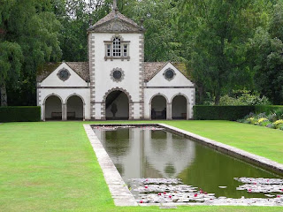
Bodnant Garden

Woodland garden at Bodnant
Bodnant Garden Executive summary by darmansjah
Bodnant Garden(Welsh: Gardd Bodnant) is a National Trust property near Tal-y-Cafn, in the county borough of Conwy, Wales. Bodnant Garden is situated above the River Conwy and overlooks the Conwy valley towards the Carneddau range of mountains.
History
 This important garden occupies an area of 32 hectares (80 acres) surrounding Bodnant House, most of which was first laid out by Henry Davis Pochin, a successful industrial chemist, from 1874 onwards until his death in 1895. Bodnant House had been built in 1792 but was remodelled by Pochin and on his death it was inherited by his daughter (whose husband became the first Baron Aberconway in 1911). The garden, but not the House or other parts of the estate, was presented to the National Trust, with an endowment, in 1949. The House was the home of the late Lord Aberconway, and members of his family continue to be actively involved in the management of the garden, its tea pavilion and car parks on behalf of the National Trust.
Attractions
The gardens are varied and include formal gardens bounded by clipped box hedges, ornamental ponds and pools and formal herbaceous borders, an enclosed laburnum arch and many rose gardens. However, Bodnant is most famous for its breeding programme, especially of varieties of Rhododendrons and azaleas examples of which are now grown throughout the world. Also noted are the collections of Magnolia, Camellia, Clematis and Hydrangea.
Origins

Begun in 1875, it is the creation of four generations of Aberconways and is divided into two parts: the upper level (around the house) features huge Italianate terraces, specimen trees and formal lawns, with paths descending to at lower level "The Dell" with a wooded valley, stream and wild garden below. Included within the Dell are the Old Mill, the mill pond with the mill race and an attractive spillway waterfall into the River Hiraethlyn, to give the delightful babbling brook through the Dell its proper name.
Of the many specimen trees within the Dell and the Woodland, notable are several Californian Redwoods. One giant redwood (sequoiadendron giganteum) measured 47.2 metres (155 ft) in height. Another tree from the western United States, the Oregon Douglas Fir Pseudotsuga menziesii was 48 metres (157 ft). From China about 1949 came the Dawn Redwood, previously known only from fossils and believed to have been extinct.
Above the Dell is "The Poem", the family mausoleum from which a network of paths leads through shrubberies and the Rosemary garden to the front lawn (separated from the old park by a ha-ha) and across the lawn to the Round garden.
↧
Mountains of the Moon, Uganda
Central Circuit, Ruwenzori Range

Executive summary by darmansjah
Round-Trip: 38 miles, 6 to 7 days
When to Go: December to March, the “dry” season. Go with guides and porters; they know the way and are not expensive.
When approaching high-altitude glaciers, you don't often hear locals say, “There are elephants here.” But everything about the Ruwenzori Range, Ptolemy's legendary Mountains of the Moon, is unexpected. Looming on the Uganda-Congo border, these peaks make up the highest range in Africa, rising to 16,765 feet at the Margherita summit of Mount Stanley. (Kilimanjaro and Kenya are taller, but they aren’t ranges.) You’ll hike three days through two 14,000-foot passes and mind-bending forests of giant groundsel and giant lobelias to get to the Bujuku Hut, base camp for those wanting to climb Mount Speke. Hike one more day to Elena Hut, base camp for those who want to climb the glaciers, and try for the summit of Mount Stanley for its unique views of the Congo Basin. Two more trail days take you over Scott Elliot Pass, the highest on the circuit at 14,344 feet, and back to the starting point for your eventual return to Kampala.
Insider Tip: Bring a pair of indestructible camp shoes impervious to moisture, such as Crocs. The circuit can be a muddy mess. Walking in the creek beds often makes for the best progress. It is essential to be able to change into something dry and reasonably comfortable for your feet at day's end.
↧
Namibia

executive summary by darmansjah
Southern Africa’s youngest nation is well known for its vast windswept deserts—the inland Kalahari and the coastal Namib—so it’s no wonder that the country’s first conservation area (established in 1907) is named for the “place of dry water.”
Etosha National Park is a wildlife sanctuary in far northern Namibia centered on Etosha Pan, a 75-mile-long (120-kilometer-long) mineral lakebed. During the June to November dry season, large numbers of elephants, giraffes, black rhinos, lions, and other game are drawn to the park’s natural and manmade watering holes. During the rains, huge numbers of flamingos arrive to feed and breed. In addition to unsurpassed big game viewing, the nearly 8,494-square-mile (22,000-square-kilometer) preserve includes numerous lodging options ranging from rustic guest farms to luxury retreats. For more intimate game viewing, head about two hours south to Mundulea Nature Reserve. Guests at the privately owned nature reserve in the Otavi Mountains encounter antelopes, leopards, hyenas, and other resident game on daylong, guided bush treks.
↧
Niseko, Japan
Best For: Powder worshippers with plenty of frequent flyer miles and a taste for hot springs and sushi
executive summary by darmansjah
Thanks to the near-constant storm cycles pumping out of neighboring Siberia, the mountains on the Japanese island of Hokkaido are globally renowned for having some of the most consistent, lightest powder on Earth. Niseko is the preeminent spot here, an amalgam of four independently owned, interconnected resorts that girdle 4,291-foot Mount Niseko Annupuri (skiable with one lift ticket). Averaging a jaw-dropping 590 inches of snow a year, there’s fresh powder more days than not on Niseko Annupuri and its abundant, lightly skied off-piste terrain (the Japanese have been inexplicably slow to embrace powder’s addictiveness). The town of Niseko, population 4,685, is an easy drive from the four separate base areas and features a laid-back, surfing-town vibe and dozens of onsen, or hot springs, for settling into after-ski comas.
Night skiing is huge here, and enormous stadium-style lights brighten 2,560 vertical feet of skiing. Deep-powder runs through illuminated nighttime forest are a Niseko specialty. Given the windstorms that periodically lash the mountain, the mountain’s perfectly spaced birch forests are often the best, most sheltered places to ski and snowboard.
Ask a Local
Canadian Clayton Kernaghan visited Niseko 13 years ago and never left. He now operates Black Diamond Lodge and Tours, which offers mountainside lodging and guided powder skiing in the area. Here are his recommendations.
Best Digs
Budget: Powder Lodge is the cheapest place to stay in town. It’s very basic.
Swank: The Vale Niseko has one of the best locations in town, ski-in and ski-out.
Best Eats
Cheap: Seico Mart, the convenience store. It might sound crazy, but the food in convenience stores here is really, really good. It’s fresh food and it’s cheap.
Gourmet: A-Bu-Cha is really good, traditional Japanese. Try the miso salmon.
Best After-Ski Party Spot
Gyu+Bar, aka the "Fridge Door" bar, spins vinyl and serves single malts. The entrance is literally a refrigerator door.
Best Rest-Day Activity
Take the 2.5-hour train ride to Sapporo, the largest city on Hokkaido.
Niseko’s Classic Run
Ride the chairlift to the top of Hanazono and go through gate four or five and drop through Rob Roy, then through Jackson, and then end up at the bottom of the mountain. It’s a powder run.
↧
↧
North Conway, New Hampshire
Best For: History-buff families in the northeastern U.S.
executive summary by darmansjah
North Conway may be less well known than many of the towns on this list, but only a few towns in North America can rival its skiing heritage. Tucked into Mount Washington Valley in the White Mountains, some of the first purpose-cut ski runs on the continent and a host of other innovations in grooming, lifts, and ski schools were developed here in the 1930s. North Conway was one of the leading lights in American skiing for decades before Western resorts rose to prominence. Much of that old New England character lives on today in the town of 2,349, where skiing is still tightly woven into the small community’s social fabric.
This may have something to do with the fact that there are no less than seven different downhill areas with an easy drive of town (and six Nordic ones). Visitors here will likely focus on three. Cranmore sits two miles from the main village. It’s an excellent starting point for families, with its revered ski school and abundant non-skiing activities, including indoor tennis, climbing walls, on-mountain tubing, and a plummeting rail-coaster ride. Attitash, seven miles up the valley, is the biggest of the bunch, with 73 runs and the region’s best terrain park. No-frills, expert-friendly Wildcat, a half-hour drive, is the wildest, tallest mountain of the three, with the most vertical and spectacular views of nearby Mount Washington, the highest peak in the Northeast. Wildcat and Attitash now share the same owners and feature interchangeable lift tickets, so if the weather is belligerent at Wildcat, which is not uncommon, you can skip 16 miles over to the more sheltered Attitash.
Ask a Local
Tom Eastman, a ski historian and reporter for Conway Daily Sun, has lived and skied in North Conway for the last 30 years. Here are his recommendations.
Best Digs
Budget: The Yankee Clipper Inn
Swank: White Mountain Hotel & Resort
Best Eats
Cheap: Horsefeathers is great for families, with good pizza, pasta, and seafood.
Gourmet: Maestro’s has incredible Italian dishes.
Best After-Ski Party Spot
Red Parka Steakhouse & Pub is a skiers’ hangout, with live music on Fridays and Saturdays, and an open mic on Mondays.
Best Rest-Day Activity
Head for the Mount Washington Observatory Weather Discovery Center right on South Main Street, where kids can learn about meteorology and the peak’s record-setting wind speeds. Then go to Farm by the River Bed and Breakfast with Stables for a sleigh ride.
North Conway’s Classic Run
The Lynx Trail at Wildcat runs top to bottom and snakes its way across the fall line while enjoying sweeping views of Tuckerman Ravine and Mount Washington.
↧
Dosewallips to Lake Quinault, Olympic National Park, Washington
Hiker: Sally Jewell, U.S. Secretary of the Interior and former CEO of REI

executive summary by darmansjah

I first hiked this route at age 12 with a group of children and a wonderful teacher, Mrs. Black. My husband, daughter, and I did the hike two summers ago. The trail goes between a beautiful temperate rain forest and rhododendron grove near Hood Canal at sea level, through beautiful alpine meadows to the snowfields of Anderson Pass, and into Enchanted Valley—home to black bears and elk. It continues along rushing Graves Creek, flows into the Quinault River, and then pours into Lake Quinault. Be prepared for wildlife, wildflowers, history, serenity, and a comfortable, three-day backpack—with a bear canister for food, of course! —Sally Jewell
Length: 34 miles
 Details: Few spots in the Lower 48 are as wild and isolated as Washington's Olympic Peninsula. Here, the Pacific slams into North America and the unrelenting weather keeps deep, wild rain forests and glacial peaks difficult to access. But this southern traverse of Olympic National Park is well worth the effort—and the extra waterproof/breathable gear—required to get a glimpse into the heart of the place.
The Enchanted Valley is an apt spot for the Secretary of the Interior to hold dear—it’s the type of pristine wilderness the National Park Service has been tasked with preserving. But it also offers a glimpse into history in the Enchanted Valley Chalet, a lodge from the 1930s that predated the designation of the park.
The untamed elements of the Olympics will often wash out the roads that get to its trailheads, so be sure to check road (and trail) conditions before you head out. Wilderness permits are required, too.
 When to Go: It can rain anytime in the Olympics, but summer can be stunning. High-pressure systems in August and September make for glorious blue-sky days.
About Jewell: While American politics seem more partisan than ever, Sally Jewell pleases both sides of the aisle. The former CEO of Recreational Equipment Inc. (REI) was quietly confirmed to the post of U.S. Secretary of the Interior by an overwhelming vote of 87 to 11 in the Senate this spring. Jewell has balanced experience in the oil and banking industries alongside conservation achievements that won her the National Audubon Society's Rachel Carson Award. One thing is for certain: Jewell plays hard in the wild—she's an experienced rock climber, mountaineer, skier, and paddler; in 2011 she made a trip up Antarctica’s Vinson Massif.

↧
Oregon Desert Trail
Hiker: Sage Clegg, thru-hiking record holder and outdoor educator

executive summary by darmansjah
My list of top trails includes some official trails and routes, but it also includes many conceptual routes, like a loop around Montana that connects my favorite places. This summer, I will become the first person to thru-hike the brand-new, 750-mile Oregon Desert Trail (ODT). People always say deserts are wasteland, but I don't see them that way at all. Deserts are filled with creatures who have a zest for life, and I want to go spend time with them. Of course, my truly epic dream route would be to extend the ODT to meet with the Idaho Centennial Trail, to the Pacific Northwest Trail, to the Pacific Crest Trail, and walk down from the Cascades back to my door in Bend, a Pacific Northwest Dryside Loop. I don't know if I will ever turn this route into reality, but it has crept into my mind. —Sage Clegg
Length: 750 miles
The Details: The Oregon Desert Trail (ODT) was designed not so much as a thru-route but as a grand tour of the little visited but grand landscapes of Oregon’s eastern desert. At a lengthy 750 miles, the trail just scratches the surface of the largest desert in the U.S., the cold, sparsely populated sage steppes of the 190,000-square-mile Great Basin Desert that stretches into Idaho, Nevada, California, and Utah.
The ODT is the brainchild of the Oregon Natural Desert Association. Volunteers and staff from the small grassroots environmental organization made their dream of showcasing eastern Oregon’s wonders when they pieced together existing trails, jeep tracks, and overland routes through vast, dry stretches of mostly Bureau of Management lands, including numerous Wilderness Study Areas whose protection status is still up in the air.
Indeed, it is not a wasteland. The trail has a subtle beauty as it passes through endless stands of big basin and Wyoming sagebrush that provide habitat for songbirds and lekking areas for sage grouse as well as a riot of springtime wildflowers, some of them found only here.
The desert shelters rock blinds and other evidence of historic native tribes and even ancient Clovis cultures who once hunted here. It crosses the Hart Mountain National Antelope Refuge and winds under the looming mass of 9,733-foot-tall, 50-mile-long Steens Mountain.
But the most dramatic section may be the final miles in the Owyhee Canyonlands, a wilderness of soaring rhyolite canyon walls where the Yellowstone hot spot caldera exploded in a fury of magma 13.8 million to 12 million years ago before it slowly shifted east to its present location under the park.
It’s not an easy trail to complete, either. Despite stops in outpost towns like Fields and Rome, there are long stretches without water or the chance to resupply. Part of Clegg’s mission on the first hike of the new trail is to report on just how it works as a thru-hike and help ONDA improve it for future visitors. Though little of the desert is protected, it makes up a section of the largest roadless area in the continental United States, 1.9 million acres of untouched land spanning Oregon, Idaho, and Nevada.
When to Go: The side seasons of spring and fall. The sage steppes of the Great Basin Desert can be frigid and snowy in winter, and summer is a tough time to find water.
About Clegg: As a wildlife biologist, Sage Clegg spends a good part of the year in the field, most recently studying desert tortoises in California’s Mojave Desert. But in summer 2013 she will be exploring the cold desert of Oregon’s Great Basin.
Clegg is more than qualified for the trip—she holds the women’s speed record for completing the big three thru-hikes in the U.S. (the Appalachian Trail, Continental Divide Trail, and Pacific Coast Trail), knocking out that triple crown of roughly 8,000 miles and a million vertical feet of elevation gain in just under 18 months. In 2011, she created her own route across California, the 1,200-mile Japhy Ryder Route from Death Valley to the Lost Coast. Her main objective on the ODT is not to beef up her hard-core hiking chops, however, but instead to draw attention to one of the last great untouched cores of wild lands in the Lower 48.
↧
Yosemite Grand Traverse, California, United States
Post Peak Pass to Tuolumne Meadows

executive summary by darmansjah
Round-Trip: 60 miles, 6 to 7 days
When to Go: Reaching as high as 12,000 feet, this trans-Sierra route is open only from mid-July to mid-September.
It’s hard to say “Sierra in summer” without thinking of granite towers rising above sparkling high-country lakes into deep blue skies. This traverse is a cheat sheet of Yosemite backcountry, touching more than a few of the real high points of the Sierra in just a week, including an ascent of Half Dome via the Cable Route.
Starting on obscure trails in the Ansel Adams Wilderness with unexpected views of the Minarets and other landmark Sierra Nevada peaks, this hike soon enters Yosemite National Park to follow the unique drainage of the Merced River. The traverse then joins the iconic John Muir Trail for a spectacular finish among the spires of the Cathedral Range. An unexpected highlight is the jaunt through the extensive drainage of the Merced River, the lifeblood of Yosemite Valley, where the route traces the headwaters through waterfalls, granite basins, and channels, interspersed with sprawling, sublime sub-alpine meadows.
Insider Tip: The trailhead logistics for this trip can be challenging, so make things easy by doing this trip with Southern Yosemite Mountain Guides, who pioneered the route and have mastered the journey from start to finish.
↧
↧
Overland Track in Tasmania, Australia
Hiker: Cheryl Strayed, author
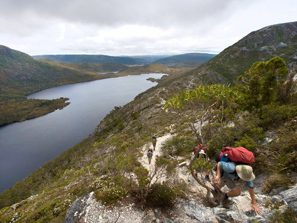
executive summary by darmansjah
The Overland Track in Tasmania, Australia. It's a 40- to 50-mile-long trail (depending on where you finish) that goes through some of the wildest and most beautiful natural terrain on the planet (or so I hear). The trail is part of the Tasmanian Wilderness World Heritage Area. Plus, it's in Tasmania! I've always wanted to go there. —Cheryl Strayed
Length: 40 miles (51 miles with the hike around Lake St. Clair)
The Details: Tasmania is a living ecological laboratory. Nearly half of Australia’s southern island state is protected. It’s home to a menagerie of famed wildlife, including the wombat, platypus, and, of course, Tasmanian devil, the largest carnivorous marsupial on the planet. It’s also an incredibly diverse landscape, encompassing everything from highland mountains to eucalyptus groves to rain forest.
Though shorter than many great thru-hikes, the Overland Track packs a big punch. The trail delves straight into the biodiverse wildlands of Cradle Mountain–Lake St. Clair National Park. It starts with a gut-busting climb up into the most mountainous highlands of the island before rambling by alpine lakes and grasslands, then diving down into the rain forest.
The trail and surrounding park are carefully managed by Tasmania Parks and Wildlife Service, who break it down into a six-day event. Slow for some, but the agency’s plan may be the best way to savor the trail, since it includes extra-credit side trips such as a scramble up Tasmania’s highest peak, 5,305-foot Mount Ossa. And it’s easy to pack light since a hut system on the trail means you don’t need a tent. Many hikers also tack on the worthwhile hike around Lake St. Clair—Australia’s deepest lake—to end the hike instead of riding a ferry across to the finish.
When to Go: Tasmania Parks and Wildlife requires hikers to book reservations and travel north to south during the prime season of October 1 and May 31. The weather can be rough in winter but you are free to hike as you please.
About Strayed: Cheryl Strayed began as the most unlikely hiker in this group. When she first headed out to thru-hike the Pacific Crest Trail—as an escape from the death of her mother, divorce, and a battle with heroin—she was woefully unprepared. So much so, in fact, that she began to walk with a pack she could barely heft and boots that fit her so badly that they shredded her feet. Strayed persevered, however, and finished 1,100 miles of the PCT a toughened hiking veteran. She recorded that experience in her memoir Wild: From Lost to Found on the Pacific Crest Trail (Knopf Doubleday Publishing Group, 2012), which hit number one on the New York Times best-seller list not just for its deft and witty depiction of the rigors of a long-distance hike, but more so for the way it reveals a woman evolving, conquering her demons, and finding meaning by putting her boots to the dirt.
↧
Pacific Crest Trail, California, Oregon, and Washington
Hiker: Scott Jurek, ultrarunning champion

executive summary by darmansjah
Thru-hiking the Pacific Crest Trail has been a lifelong dream. The sheer beauty and variety of the great Pacific mountain ranges along with the journey of a long thru-hike traversing the U.S. north to south has been the main allure. While I have many trails on my list all over the world, exploring my own country ranks highest. In fact, I am heading off today with my wife for a weeklong section hike of the PCT! —Scott Jurek
Length: 2,650 miles
The Details: Alongside the Appalachian Trail and the Continental Divide Trail, the Pacific Crest Trail (PCT) anchors the trifecta of big daddy thru-hikes in the United States. Each claims a distinct history, beauty, and province over a chunk of North American geography, but the PCT may be the most grand, running across the country via the heights of the lordly Sierra and Cascade ranges.
It’s no easy accomplishment to tick off in one attempt, requiring savvy logistics and resupply (especially when it comes to long stretches sans civilization), good luck with the weather, and fleet feet. The reward is a grand tour of seven national parks and a continent’s worth of national forests, state parks, and wilderness areas. On the journey, hikers tromp through the Mojave Desert, summit 13,153-foot Forester Pass between Sequoia and Kings Canyon National Parks, stride along in Yosemite’s Tuolumne Meadows, make their way into the volcanoes of the Cascades via Lassen Volcanic National Park, and end up in British Columbia’s E.C. Manning Provincial Park.
When to Go: Most hikers begin on the Mexican border in April and finish in October. The trick is to miss the spring snow in the Sierra and fall snow in the Cascades.
About Jurek: Scott Jurek is tough to beat. The ultrarunner has won most of the sport’s big events, including the Western States 100-Mile Endurance Run (seven times in a row from 1999 to 2005), Badwater Ultramarathon (twice), the Hardrock 100-Mile Endurance Run, Spartathon, and the Ultramarathon Caballo Blanco. He once held the U.S. record for distance run in 24 hours (167.5 miles!) and held course records at Western States and Badwater. He’s also a passionate vegan, which he claims improves his performance, overall health, bank account, and sheer enjoyment of food. In the book Eat and Run: My Unlikely Journey to Ultramarathon Greatness (Houghton Mifflin Harcourt, 2012), he explains his plant-based philosophy and how it has made him a running machine.
↧
Palawan, Philippines

executive summary by darmansjah
Palawan’slimestone karst cliffs, coral atolls, mangrove forests, sugar-white sandy beaches, and extensive fringing reefs create one of the Philippines' most biodiverse terrestrial and marine environments. Designated as a fish and wildlife sanctuary in 1967, the Philippines' largest (in total land area) province encompasses nearly 1,240 miles (1,995 kilometers) of coastline stretching across 1,768 islands.
On the main island (also named Palawan) near Sabang, hike the three-mile (five-kilometer) Monkey Trail to Puerto Princesa Subterranean River National Park's navigable underground river. The five-mile (eight-kilometer) coastal rain forest route is home to long-tailed macaques, blue-naped parrots, and other indigenous wildlife. In the province’s northern Calamianes islands, Coron Island is considered one of the world’s top scuba diving destinations, offering World War II-vintage wreck diving and snorkeling in calm, crystalline waters. Nearby Culion Island, a former leper colony surrounded by sea grass beds and coral reefs, is an emerging ecotourism destination worth a day trip.
↧